File:The Amazing Race 5 map.png

Size of this preview: 800 × 338 pixels. Other resolutions: 320 × 135 pixels | 640 × 270 pixels | 1,480 × 625 pixels.
Original file (1,480 × 625 pixels, file size: 67 KB, MIME type: image/png)
Captions
Captions
Add a one-line explanation of what this file represents
| The Amazing Race maps |
| Original U.S. version |
| Countries visited · US states |
| Route maps |
| Seasons: 1 · 2 · 3 · 4 · 5 · 6 · 7 · 8 · 9 · 10 · 11 · 12 · 13 · 14 · 15 · 16 · 17 · 18 · 19 (svg) · 20 (svg) · 21 · 22 · 23 · 24 · 25 · 26 · 27 · 28 ˑ 29 ˑ 30 ˑ 31 ˑ 32 ˑ 33 ˑ 34 ˑ 35 ˑ 36 |

|
This map image could be re-created using vector graphics as an SVG file. This has several advantages; see Commons:Media for cleanup for more information. If an SVG form of this image is available, please upload it and afterwards replace this template with
{{vector version available|new image name}}.
It is recommended to name the SVG file “The Amazing Race 5 map.svg”—then the template Vector version available (or Vva) does not need the new image name parameter. |
Summary edit
| Description |
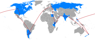
English: The Route Map of The Amazing Race 5, recreated with black dot leg stops |
| Date | (UTC) |
| Source | BlankMap-World.png |
| Author | ApprenticeFan work |
| Other versions |
 |
Licensing edit
| I, the copyright holder of this work, release this work into the public domain. This applies worldwide. In some countries this may not be legally possible; if so: I grant anyone the right to use this work for any purpose, without any conditions, unless such conditions are required by law. |
File history
Click on a date/time to view the file as it appeared at that time.
| Date/Time | Thumbnail | Dimensions | User | Comment | |
|---|---|---|---|---|---|
| current | 01:46, 11 March 2013 | | 1,480 × 625 (67 KB) | ApprenticeFan (talk | contribs) | improved finish line dot colors |
| 07:50, 29 July 2012 |  | 1,480 × 625 (69 KB) | ApprenticeFan (talk | contribs) | Map of The Amazing Race 5 with dotted locations Category:The Amazing Race |
You cannot overwrite this file.
File usage on Commons
The following 3 pages use this file:
File usage on other wikis
The following other wikis use this file:
- Usage on en.wikipedia.org
- Usage on fr.wikipedia.org
- Usage on no.wikipedia.org
- Usage on pl.wikipedia.org