File:The Black Bridge - geograph.org.uk - 952205.jpg
No higher resolution available.
The_Black_Bridge_-_geograph.org.uk_-_952205.jpg (640 × 480 pixels, file size: 110 KB, MIME type: image/jpeg)
Captions
Captions
Add a one-line explanation of what this file represents
Summary edit
| Description |
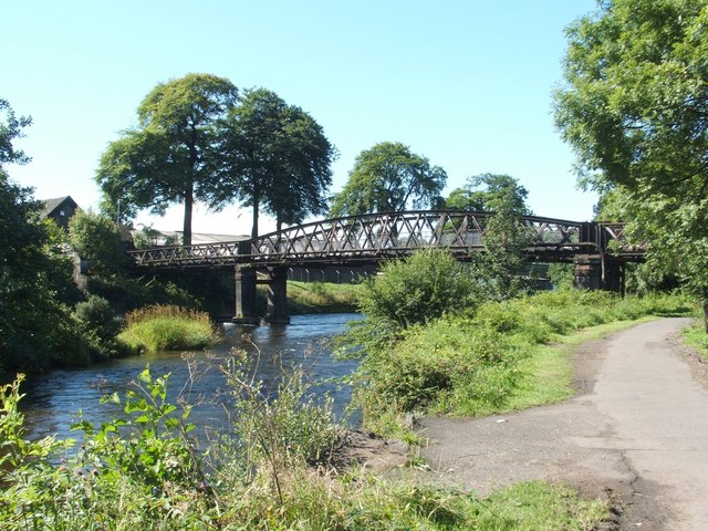
English: The Black Bridge. This bridge used to carry a railway line over the river (see 1131986), towards Dillichip Works (compare 1092625), but the line fell into disuse long ago.
The bridge was subsequently used by pedestrians, but, at the time of writing, it has been closed to the public for several year. On this side of the river, the cycle path (NCN Route 7) passes under the bridge. The buildings on the other side of the river are bonded warehouses, a fact that probably accounts for the blackness of the trees here, if not that of the bridge itself (see 971102). |
| Date | |
| Source | From geograph.org.uk |
| Author | Lairich Rig |
| Attribution (required by the license) | Lairich Rig / The Black Bridge / |
| Camera location | | View this and other nearby images on: OpenStreetMap |
|---|
_heading:202.00&language=en)
| Object location | | View this and other nearby images on: OpenStreetMap |
|---|
_heading:202.00&language=en)
Licensing edit

|
This image was taken from the Geograph project collection. See this photograph's page on the Geograph website for the photographer's contact details. The copyright on this image is owned by Lairich Rig and is licensed for reuse under the Creative Commons Attribution-ShareAlike 2.0 license.
|
This file is licensed under the Creative Commons Attribution-Share Alike 2.0 Generic license.
Attribution: Lairich Rig
- You are free:
- to share – to copy, distribute and transmit the work
- to remix – to adapt the work
- Under the following conditions:
- attribution – You must give appropriate credit, provide a link to the license, and indicate if changes were made. You may do so in any reasonable manner, but not in any way that suggests the licensor endorses you or your use.
- share alike – If you remix, transform, or build upon the material, you must distribute your contributions under the same or compatible license as the original.
File history
Click on a date/time to view the file as it appeared at that time.
| Date/Time | Thumbnail | Dimensions | User | Comment | |
|---|---|---|---|---|---|
| current | 14:37, 22 February 2011 | | 640 × 480 (110 KB) | GeographBot (talk | contribs) | == {{int:filedesc}} == {{Information |description={{en|1=The Black Bridge This bridge used to carry a railway line over the river (see 1131986), towards Dillichip Works (compare 1092625), but the line fell into disuse long ago. The bridge was s |
You cannot overwrite this file.
File usage on Commons
There are no pages that use this file.