File:The King's Head - geograph.org.uk - 618398.jpg
No higher resolution available.
The_King's_Head_-_geograph.org.uk_-_618398.jpg (640 × 480 pixels, file size: 49 KB, MIME type: image/jpeg)
Captions
Captions
Add a one-line explanation of what this file represents
Summary
edit| Description |
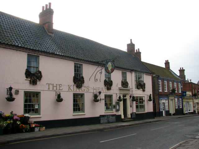
English: The King's Head This 18th century building with two storeys and a dormer attic is located on High Street. Holt is a rural Norfolk town with a market place, and a High Street lined by interesting Georgian houses and cottages, pubs and tearooms as well as unusual shops. Many of the former court yards and tradesmen's yards have been converted into shops or accommodation. In 1066 Holt already had a market and a port (the coastal village of Cley being named in the Domesday Book as the port of Holt), five water mills and twelve plough teams. The town survived the Plague of 1348, and by 1556 a school had been opened. The school (a public school since 1900) was founded by Sir John Gresham, and is described as one of the leading schools in the country. In 1708 the town was badly damaged by a fire, which destroyed most of the houses and left the church in the isolated position it occupies today. In Victorian times, Holt had a population of around 1700 and a daily coach service to Cromer, Norwich and London; the railway arrived in 1884. |
| Date | |
| Source | From geograph.org.uk |
| Author | Evelyn Simak |
| Other versions |
|
| Attribution (required by the license) | Evelyn Simak / The King's Head / |


| Object location | | View this and other nearby images on: OpenStreetMap |
|---|
Licensing
edit

|
This image was taken from the Geograph project collection. See this photograph's page on the Geograph website for the photographer's contact details. The copyright on this image is owned by Evelyn Simak and is licensed for reuse under the Creative Commons Attribution-ShareAlike 2.0 license.
|
This file is licensed under the Creative Commons Attribution-Share Alike 2.0 Generic license.
Attribution: Evelyn Simak
- You are free:
- to share – to copy, distribute and transmit the work
- to remix – to adapt the work
- Under the following conditions:
- attribution – You must give appropriate credit, provide a link to the license, and indicate if changes were made. You may do so in any reasonable manner, but not in any way that suggests the licensor endorses you or your use.
- share alike – If you remix, transform, or build upon the material, you must distribute your contributions under the same or compatible license as the original.
File history
Click on a date/time to view the file as it appeared at that time.
| Date/Time | Thumbnail | Dimensions | User | Comment | |
|---|---|---|---|---|---|
| current | 03:51, 7 February 2011 | | 640 × 480 (49 KB) | GeographBot (talk | contribs) | == {{int:filedesc}} == {{Information |description={{en|1=The King's Head This 18th century building with two storeys and a dormer attic is located on High Street. Holt is a rural Norfolk town with a market place, and a High Street lined by interesting Ge |
You cannot overwrite this file.
File usage on Commons
The following 4 pages use this file: