File:The Knockan Wall - geograph.org.uk - 824976.jpg
No higher resolution available.
The_Knockan_Wall_-_geograph.org.uk_-_824976.jpg (640 × 427 pixels, file size: 286 KB, MIME type: image/jpeg)
Captions
Captions
Add a one-line explanation of what this file represents
Summary
edit
| Description |
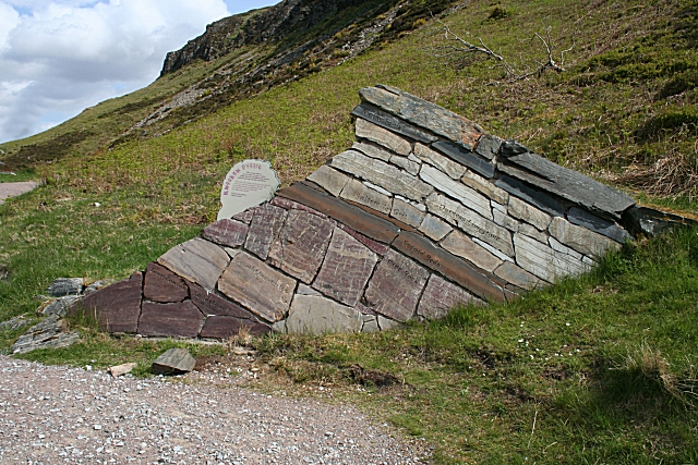
English: The Knockan Wall This wall is a model of the different units of rock which occur at Knockan Crag. Each layer is carved with the name of the rock unit which it represents, but the lettering is hard to read in this photograph. Grom lower left to upper right they are Lewisian Gneiss, Torridonian Sandstone, Cambrian Quartzite, Pipe Rock, Fucoid Beds, Salterella Grit, Durness Limestone and Moine Schist. Someone pointed out that one of the blocks of Pipe Rock has been built in upside-down. |
| Date | |
| Source | From geograph.org.uk |
| Author | Anne Burgess |
| Attribution (required by the license) | Anne Burgess / The Knockan Wall / |
| Camera location | | View this and other nearby images on: OpenStreetMap |
|---|
_heading:67.00&language=en)
| Object location | | View this and other nearby images on: OpenStreetMap |
|---|
_heading:67.00&language=en)
Licensing
edit

|
This image was taken from the Geograph project collection. See this photograph's page on the Geograph website for the photographer's contact details. The copyright on this image is owned by Anne Burgess and is licensed for reuse under the Creative Commons Attribution-ShareAlike 2.0 license.
|
This file is licensed under the Creative Commons Attribution-Share Alike 2.0 Generic license.
Attribution: Anne Burgess
- You are free:
- to share – to copy, distribute and transmit the work
- to remix – to adapt the work
- Under the following conditions:
- attribution – You must give appropriate credit, provide a link to the license, and indicate if changes were made. You may do so in any reasonable manner, but not in any way that suggests the licensor endorses you or your use.
- share alike – If you remix, transform, or build upon the material, you must distribute your contributions under the same or compatible license as the original.
File history
Click on a date/time to view the file as it appeared at that time.
| Date/Time | Thumbnail | Dimensions | User | Comment | |
|---|---|---|---|---|---|
| current | 17:11, 20 February 2011 | | 640 × 427 (286 KB) | GeographBot (talk | contribs) | == {{int:filedesc}} == {{Information |description={{en|1=The Knockan Wall This wall is a model of the different units of rock which occur at Knockan Crag. Each layer is carved with the name of the rock unit which it represents, but the lettering is hard t |
You cannot overwrite this file.
File usage on Commons
There are no pages that use this file.
File usage on other wikis
The following other wikis use this file:
- Usage on de.wikipedia.org