File:The LMS Station, rail side, Stratford-upon-Avon (geograph 6783150).jpg
Size of this preview: 800 × 502 pixels. Other resolutions: 320 × 201 pixels | 640 × 402 pixels | 1,024 × 643 pixels.
Original file (1,024 × 643 pixels, file size: 183 KB, MIME type: image/jpeg)
Captions
Captions
Add a one-line explanation of what this file represents
Summary edit
.jpg&action=edit§ion=1)
| Description |
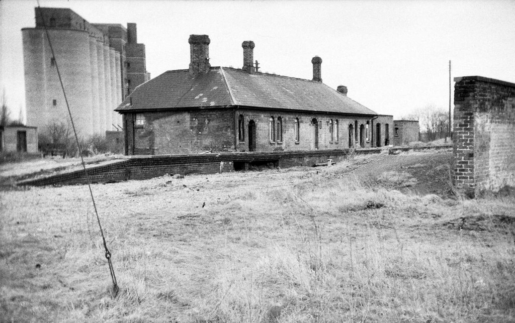
English: The LMS Station, rail side, Stratford-upon-Avon The LMS Station at Stratford was the only station of any importance on the Stratford-upon-Avon & Midland Junction Railway - a rural trailway that meandered across the southern midlands from Ravenstone Wood Junc (near Bedford) in the east, to Broom Junc (near Alcester) in the west. The view here is towards the east. Withdrawal of the passenger service inevitably came early; that to the west of Stratford ended in May 1949, & that to the east in April 1952. It remained open as a through route for goods trains (notably ore trains from Northamptonshire to South Wales) until 1960. West of Stratford then closed completely, but a goods service to Stratford from the east lasted until 1965. All has gone now & the trackbed has been used for the A4390. For a view of the road-side elevation see: SP1954 : The LMS Station, road side, Stratford-upon-Avon. |
| Date | |
| Source | From geograph.org.uk |
| Author | Martin Tester |
| Permission (Reusing this file) |
Creative Commons Attribution Share-alike license 2.0 |
| Attribution (required by the license) | Martin Tester / The LMS Station, rail side, Stratford-upon-Avon / |
.jpg)
| Camera location | | View this and other nearby images on: OpenStreetMap |
|---|
.jpg¶ms=052.184164_N_-001.710795_E_globe:Earth_type:camera_source:geograph-osgb36(SP19875403)_heading:67.00&language=en)
| Object location | | View this and other nearby images on: OpenStreetMap |
|---|
.jpg¶ms=052.184320_N_-001.710350_E_globe:Earth_class:object_type:object_source:geograph-osgb36(SP1990054047)_heading:67.00&language=en)
Licensing edit
.jpg&action=edit§ion=2)

|
This image was taken from the Geograph project collection. See this photograph's page on the Geograph website for the photographer's contact details. The copyright on this image is owned by Martin Tester and is licensed for reuse under the Creative Commons Attribution-ShareAlike 2.0 license.
|
This file is licensed under the Creative Commons Attribution-Share Alike 2.0 Generic license.
Attribution: Martin Tester
- You are free:
- to share – to copy, distribute and transmit the work
- to remix – to adapt the work
- Under the following conditions:
- attribution – You must give appropriate credit, provide a link to the license, and indicate if changes were made. You may do so in any reasonable manner, but not in any way that suggests the licensor endorses you or your use.
- share alike – If you remix, transform, or build upon the material, you must distribute your contributions under the same or compatible license as the original.
File history
Click on a date/time to view the file as it appeared at that time.
| Date/Time | Thumbnail | Dimensions | User | Comment | |
|---|---|---|---|---|---|
| current | 19:16, 11 April 2021 | | 1,024 × 643 (183 KB) | Lamberhurst (talk | contribs) | Transferred from geograph.co.uk using [https://tools.wmflabs.org/geograph2commons/ geograph2commons] |
You cannot overwrite this file.
File usage on Commons
The following page uses this file:
.jpg&oldid=671514711)