File:The Nongkrem Dance of Meghalaya India.jpg

Size of this preview: 800 × 600 pixels. Other resolutions: 320 × 240 pixels | 640 × 480 pixels | 1,024 × 768 pixels | 1,280 × 960 pixels | 2,560 × 1,920 pixels | 4,608 × 3,456 pixels.
Original file (4,608 × 3,456 pixels, file size: 6.71 MB, MIME type: image/jpeg)
Captions
Captions
Add a one-line explanation of what this file represents
Summary
edit
| Description |
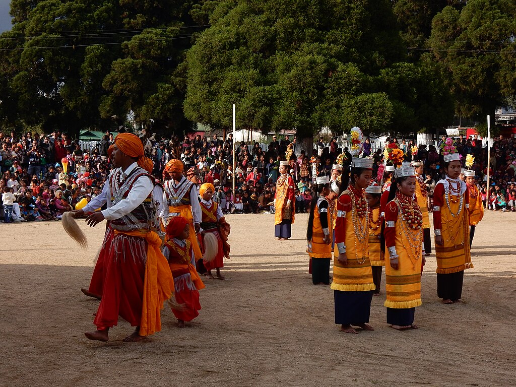
English: The Nongkrem Dance Festival of Meghalaya is celebrated during autumn at Smit, the cultural centre of the Khasi Hills. The two day celebration is the most popular festival for the inhabitants of Khasi hills. It can be termed as a grand carnival that involves flow of wealth, sacrifice of animals and an environment of religious fervour. The venue of the festival celebration is SMIT, an agricultural hamlet about 11km from the main town Shillong partially on the Jowai-Laitumbai Highway.
The Nongkrem dance form is associated with the religious beliefs of the Khasi people, and is an annual event in the Khasi hills. This festival locally named Ka Pomblang Nongrem, which over the years has been popularly termed as Nongkrem dance Festival. Nongkrem Dance Festival is performed to appease the all-powerful Goddess Ka Blei Synshar for a rich bumper harvest and prosperity of the people. The dance is performed by young unmarried Khasi girls and has the typical essence of rich cultural heritage and traditional belief passed on through generations. The costume is in bright yellow ‘Jainsem’ with intricate embroidered panels and tassels and a silver crown headgear with autumn bloom of orchids and other flowers. Coral Beads of varied sizes form the intricate part of the necklace made out of 24 Carat gold, which is also part of the enchanting costume in yellow heavily decked attire. The girls dance in small groups of four and move in a slow rhythmic toe movement of feet in a circular path surrounded by energetic youth men who also wear the traditional costume.
|
||
| Date | |||
| Source | Own work | ||
| Author | Debanutosh |
| Camera location | | View this and other nearby images on: OpenStreetMap |
|---|
Licensing
edit
I, the copyright holder of this work, hereby publish it under the following license:
This file is licensed under the Creative Commons Attribution-Share Alike 4.0 International license.
- You are free:
- to share – to copy, distribute and transmit the work
- to remix – to adapt the work
- Under the following conditions:
- attribution – You must give appropriate credit, provide a link to the license, and indicate if changes were made. You may do so in any reasonable manner, but not in any way that suggests the licensor endorses you or your use.
- share alike – If you remix, transform, or build upon the material, you must distribute your contributions under the same or compatible license as the original.
This media was uploaded as part of Wiki Loves Folklore 2024 international photographic contest. Other languages:
|
File history
Click on a date/time to view the file as it appeared at that time.
| Date/Time | Thumbnail | Dimensions | User | Comment | |
|---|---|---|---|---|---|
| current | 13:47, 1 March 2024 | | 4,608 × 3,456 (6.71 MB) | Debanutosh (talk | contribs) | Uploaded own work with UploadWizard |
You cannot overwrite this file.
File usage on Commons
The following 4 pages use this file: