File:The Persian Gulf (MODIS 2016-09-29).jpg

Original file (2,790 × 1,868 pixels, file size: 467 KB, MIME type: image/jpeg)
Captions
Captions
Summary edit
.jpg&action=edit§ion=1)
| Description |
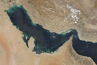
English: The Moderate Resolution Imaging Spectroradiometer (MODIS) aboard NASA’s Terra satellite captured a true-color image of the Persian Gulf on September 17, 2016.
The Persian Gulf is a shallow inland sea that lies between the Arabian Peninsula and Iran. It extends more than 600 miles (970 km) between the delta of the Shat al Arab River in the west to the Strait of Hormuz in the west. It Strait of Hormuz links the waters to the Gulf of Oman. Jewel-toned colors mark the sediment which are part of the inflow from the Shat al Arab River - a long river which flows for 615 mi (989 km) and carries the water of the Tigris and the Euphrates Rivers. In the southeast, additional roughly circular jewel tones mark coral reefs off the coast of the United Arab Emirates. From the United Arab Republic moving clockwise, the countries that sit along the Persian Gulf are Saudi Arabia, Qatar, Bahrain, Kuwait, Iraq, and Iran. The Zagros Mountains lie north of the Persian Gulf in Iran. The Arabian Peninsula in the southwest is covered with vast tan, pink and white sand deserts. |
||
| Date | Taken on 17 September 2016 | ||
| Source |
The Persian Gulf (direct link)
|
||
| Author | Jeff Schmaltz, MODIS Land Rapid Response Team, NASA GSFC |
| This media is a product of the Terra mission Credit and attribution belongs to the mission team, if not already specified in the "author" row |
Licensing edit
.jpg&action=edit§ion=2)
| This file is in the public domain in the United States because it was solely created by NASA. NASA copyright policy states that "NASA material is not protected by copyright unless noted". (See Template:PD-USGov, NASA copyright policy page or JPL Image Use Policy.) | ||
 |
Warnings:
|
File history
Click on a date/time to view the file as it appeared at that time.
| Date/Time | Thumbnail | Dimensions | User | Comment | |
|---|---|---|---|---|---|
| current | 19:18, 15 February 2024 | | 2,790 × 1,868 (467 KB) | OptimusPrimeBot (talk | contribs) | #Spacemedia - Upload of http://modis.gsfc.nasa.gov/gallery/images/image09292016_250m.jpg via Commons:Spacemedia |
You cannot overwrite this file.
File usage on Commons
There are no pages that use this file.
.jpg&oldid=852067266)