File:The Province of Ulster Divided into its Counties and ye Counties into their severall Barronies &c. with the Great Roads - By H. Moll Geographer - btv1b53056868x.jpg

Original file (3,704 × 2,688 pixels, file size: 1.67 MB, MIME type: image/jpeg)
Captions
Captions
Summary
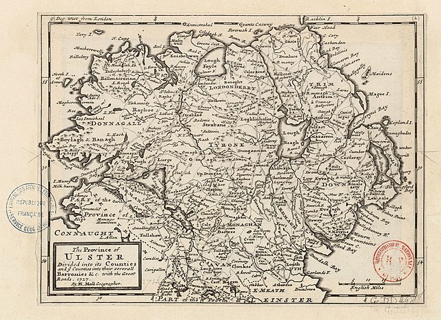
edit| English: The Province of Ulster Divided into its Counties and ye Counties into their Severall Barronies &c. with the Great Roads 1727 by H. Moll Geographer
( |
|||||||||||||||||||||||||||
|---|---|---|---|---|---|---|---|---|---|---|---|---|---|---|---|---|---|---|---|---|---|---|---|---|---|---|---|
| Author |
|
||||||||||||||||||||||||||
| Title |
English: The Province of Ulster Divided into its Counties and ye Counties into their Severall Barronies &c. with the Great Roads 1727 by H. Moll Geographer |
||||||||||||||||||||||||||
| Description |
English: Moll's map of the Province of Ulster and its counties Antrim, Ardmagh (Armagh), Cavan, Donnagall (Donegal), Down, Farmanagh (Fermanagh), Londonderry, Monaghan, and Tyrone, printed separately 1727 and reprinted as map 2 (listed as "The Province of Ulster, divided into its Counties, and the Counties into their several Baronies, with the Great Roads.") in his 1728 Set of Twenty New and Correct Maps of Ireland...
Français : Sujet : Divisions politiques et administratives
Routes Ulster, Province d' -- Divisions politiques et administratives Ulster, Province d' -- Routes Échelle(s) : 20 English Miles [= 4,4 cm] Appartient à l’ensemble documentaire : AnvilEur Couverture : Irlande Royaume-Uni – Irlande du Nord Langue : anglais Éditeur : [H. Moll] (London) |
||||||||||||||||||||||||||
| Date | 1727, later reprinted 1728 and after | ||||||||||||||||||||||||||
| Dimensions | height: 28 cm (11 in); width: 21 cm (8.2 in) | ||||||||||||||||||||||||||
| Collection |
|
||||||||||||||||||||||||||
| References |
Français : Notice de recueil : http://catalogue.bnf.fr/ark:/12148/cb40577015h
Appartient à : Collection d'Anville ; 02714 Notice du catalogue : http://catalogue.bnf.fr/ark:/12148/cb41204027z |
||||||||||||||||||||||||||
| Source/Photographer |
Français : Bibliothèque nationale de France, département Cartes et plans, GE DD-2987 (2714)
Bibliothèque nationale de France |
||||||||||||||||||||||||||
| Permission (Reusing this file) |
|
||||||||||||||||||||||||||
| Other versions |
|
||||||||||||||||||||||||||


.jpg)


| Annotations | This image is annotated: View the annotations at Commons |
File history
Click on a date/time to view the file as it appeared at that time.
| Date/Time | Thumbnail | Dimensions | User | Comment | |
|---|---|---|---|---|---|
| current | 03:08, 15 August 2022 | | 3,704 × 2,688 (1.67 MB) | Gzen92Bot (talk | contribs) | Gallica btv1b53056868x |
You cannot overwrite this file.
File usage on Commons
The following 6 pages use this file:
- File:Ireland Divided into Its Provinces and Counties &c (btv1b53056672w).jpg
- File:The Counties of Antrim, Ardmagh and Down - By H. Moll Geographer - btv1b530565786.jpg
- File:The Counties of Donnagal, Tyrone and Londonderry - By H. Moll Geographer - btv1b53057014c.jpg
- File:The Counties of Farmanagh, Leitrim, Cavan, and Monaghan - By H. Moll Geographer - btv1b530563842.jpg
- File:The Counties of Longford, Meath and Eastmeath - By H. Moll Geographer - btv1b530565623.jpg
- File:The Province of Ulster Divided into its Counties and ye Counties into their severall Barronies &c. with the Great Roads - By H. Moll Geographer - btv1b53056868x.jpg