File:The Red Corridor ver 1.PNG
No higher resolution available.
The_Red_Corridor_ver_1.PNG (530 × 599 pixels, file size: 146 KB, MIME type: image/png)
Captions
Captions
Add a one-line explanation of what this file represents
Summary
edit
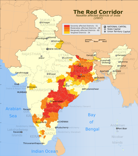
| Description | The Red Corridor. A relatively underdeveloped region in eastern India that has w:Naxalite communist militant activity. |
| Date | (UTC) |
| Source | |
| Author |
|
| This is a retouched picture, which means that it has been digitally altered from its original version. The original can be viewed here: India Red Corridor map.png:
|
I, the copyright holder of this work, hereby publish it under the following licenses:
This file is licensed under the Creative Commons Attribution-Share Alike 3.0 Unported license.
- You are free:
- to share – to copy, distribute and transmit the work
- to remix – to adapt the work
- Under the following conditions:
- attribution – You must give appropriate credit, provide a link to the license, and indicate if changes were made. You may do so in any reasonable manner, but not in any way that suggests the licensor endorses you or your use.
- share alike – If you remix, transform, or build upon the material, you must distribute your contributions under the same or compatible license as the original.

|
Permission is granted to copy, distribute and/or modify this document under the terms of the GNU Free Documentation License, Version 1.2 or any later version published by the Free Software Foundation; with no Invariant Sections, no Front-Cover Texts, and no Back-Cover Texts. A copy of the license is included in the section entitled GNU Free Documentation License. |
You may select the license of your choice.
Original upload log
edit
This image is a derivative work of the following images:
- File:India_Red_Corridor_map.png licensed with Cc-by-sa-3.0, GFDL
- 2008-10-27T17:01:57Z Hunnjazal 530x599 (378273 Bytes) {{Information |Description=The Red Corridor. A relatively underdeveloped region in eastern India that has [[w:Naxalite]] communist militant activity. |Source=*[[:Image:India_Naxal_affected_districts_map
File history
Click on a date/time to view the file as it appeared at that time.
| Date/Time | Thumbnail | Dimensions | User | Comment | |
|---|---|---|---|---|---|
| current | 06:15, 31 October 2009 | | 530 × 599 (146 KB) | Gagan11111 (talk | contribs) | {{Information |Description=The Red Corridor. A relatively underdeveloped region in eastern India that has w:Naxalite communist militant activity. |Source=*File:India_Red_Corridor_map.png |Date=2009-10-31 06:14 (UTC) |Author=*[[:File:India_Red_Co |
You cannot overwrite this file.
File usage on Commons
There are no pages that use this file.
File usage on other wikis
The following other wikis use this file:
- Usage on ar.wikipedia.org
- Usage on cs.wikipedia.org
- Usage on en.wikipedia.org
- Usage on es.wikipedia.org
- Usage on fr.wikipedia.org
- Usage on mr.wikipedia.org
- Usage on pnb.wikipedia.org
- Usage on pt.wikipedia.org
- Usage on ta.wikipedia.org
- Usage on www.wikidata.org
- Usage on zh.wikipedia.org