File:The Three Bridges and a frozen canal - geograph.org.uk - 1183861.jpg
The_Three_Bridges_and_a_frozen_canal_-_geograph.org.uk_-_1183861.jpg (640 × 480 pixels, file size: 64 KB, MIME type: image/jpeg)
Captions
Captions
Summary edit
| Description |
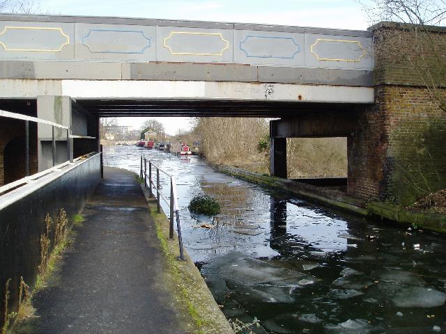
English: The Three Bridges and a frozen canal The Three Bridges is a unique transport intersection, designed and built by Isambard Kingdom Brunel. It was to be his last project before he died on 15th September 1859 just two months after its completion.
The correct name for it should be Windmill Bridge - named after the Southall Mill, which stood on the south-western side of the original canal bridge which was first built in the 1790's when the canal was cut. J.M.W. Turner painted this windmill in 1806. File:Joseph_Mallord_William_Turner_014.jpg Known locally as The Three Bridges, the name is a misnomer as there are in fact only two bridges - the road bridge over the canal and the canal bridge over the railway. The canal is conveyed through an 8 ft cast-iron trough over the railway, with the road on a brick & cast-iron girder bridge above. The Three Bridges was constructed as a result of the Brentford Branch line being built to connect the Great Western Railway at Southall to the docks at Brentford. Which was opened in July 1859. Brunel chose the location for the Three Bridges intersection where the canal was already crossed by Windmill Lane. The Three Bridges has been designated a Scheduled Ancient Monument by English Heritage. There is a 3 ton weight and 6' 6" width restrictions on the road bridge. |
| Date | |
| Source | From geograph.org.uk |
| Author | J Taylor |
| Attribution (required by the license) | J Taylor / The Three Bridges and a frozen canal / |
| Camera location | | View this and other nearby images on: OpenStreetMap |
|---|
_heading:112.00&language=en)
| Object location | | View this and other nearby images on: OpenStreetMap |
|---|
_heading:112.00&language=en)
Licensing edit

|
This image was taken from the Geograph project collection. See this photograph's page on the Geograph website for the photographer's contact details. The copyright on this image is owned by J Taylor and is licensed for reuse under the Creative Commons Attribution-ShareAlike 2.0 license.
|
- You are free:
- to share – to copy, distribute and transmit the work
- to remix – to adapt the work
- Under the following conditions:
- attribution – You must give appropriate credit, provide a link to the license, and indicate if changes were made. You may do so in any reasonable manner, but not in any way that suggests the licensor endorses you or your use.
- share alike – If you remix, transform, or build upon the material, you must distribute your contributions under the same or compatible license as the original.
File history
Click on a date/time to view the file as it appeared at that time.
| Date/Time | Thumbnail | Dimensions | User | Comment | |
|---|---|---|---|---|---|
| current | 22:13, 25 February 2011 | | 640 × 480 (64 KB) | GeographBot (talk | contribs) | == {{int:filedesc}} == {{Information |description={{en|1=The Three Bridges and a frozen canal The Three Bridges is a unique transport intersection, designed and built by Isambard Kingdom Brunel. It was to be his last project before he died on 15th Septemb |
You cannot overwrite this file.
File usage on Commons
There are no pages that use this file.