File:The Wherryman's Way - geograph.org.uk - 1551424.jpg
No higher resolution available.
The_Wherryman's_Way_-_geograph.org.uk_-_1551424.jpg (640 × 480 pixels, file size: 145 KB, MIME type: image/jpeg)
Captions
Captions
Add a one-line explanation of what this file represents
Summary
edit
| Description |
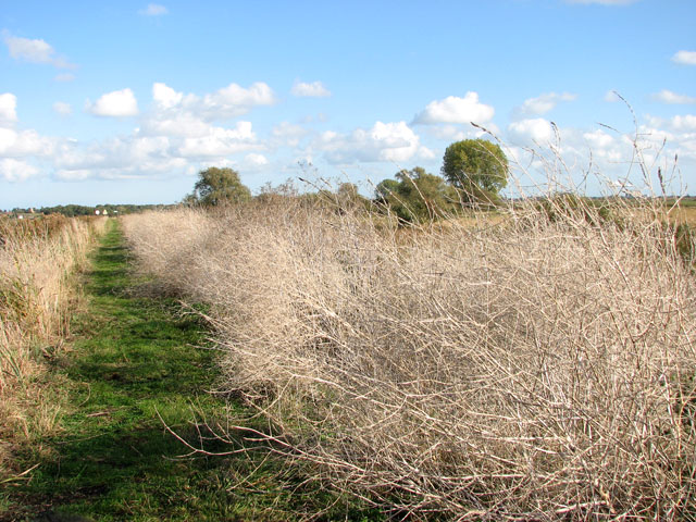
English: The Wherryman's Way. Following the Wherryman's Way long distance footpath in westerly direction along Short Dike, approaching the River Yare. Only white dried-out skeletons are left of the wild mustard (Brassica Kaber) which here lined the path in great abundance > 1335110 during the summer months. Short Dike is a channel linking Rockland Broad and the Yare.
The Wherryman's Way is a 35-mile long distance footpath following the route of the Broads trading wherries between Norwich and Great Yarmouth. The route takes its name from the wherry - a large cargo-carrying barge whose black sails used to be a common sight on these waters. Ten circular village walks branch off this path along the way. |
| Date | |
| Source | From geograph.org.uk |
| Author | Evelyn Simak |
| Attribution (required by the license) | Evelyn Simak / The Wherryman's Way / |
| Camera location | | View this and other nearby images on: OpenStreetMap |
|---|
_heading:67.00&language=en)
| Object location | | View this and other nearby images on: OpenStreetMap |
|---|
_heading:67.00&language=en)
Licensing
edit

|
This image was taken from the Geograph project collection. See this photograph's page on the Geograph website for the photographer's contact details. The copyright on this image is owned by Evelyn Simak and is licensed for reuse under the Creative Commons Attribution-ShareAlike 2.0 license.
|
This file is licensed under the Creative Commons Attribution-Share Alike 2.0 Generic license.
Attribution: Evelyn Simak
- You are free:
- to share – to copy, distribute and transmit the work
- to remix – to adapt the work
- Under the following conditions:
- attribution – You must give appropriate credit, provide a link to the license, and indicate if changes were made. You may do so in any reasonable manner, but not in any way that suggests the licensor endorses you or your use.
- share alike – If you remix, transform, or build upon the material, you must distribute your contributions under the same or compatible license as the original.
File history
Click on a date/time to view the file as it appeared at that time.
| Date/Time | Thumbnail | Dimensions | User | Comment | |
|---|---|---|---|---|---|
| current | 14:46, 3 March 2011 | | 640 × 480 (145 KB) | GeographBot (talk | contribs) | == {{int:filedesc}} == {{Information |description={{en|1=The Wherryman's Way Following the Wherryman's Way long distance footpath in westerly direction along Short Dike, approaching the River Yare. Only white dried-out skeletons are left of the wild musta |
You cannot overwrite this file.
File usage on Commons
There are no pages that use this file.