File:The Zheng He expeditions - Jap.jpg
Size of this preview: 800 × 536 pixels. Other resolutions: 320 × 214 pixels | 640 × 429 pixels | 1,024 × 686 pixels | 1,280 × 857 pixels | 1,575 × 1,055 pixels.
Original file (1,575 × 1,055 pixels, file size: 186 KB, MIME type: image/jpeg)
Captions
Captions
Add a one-line explanation of what this file represents

|
This map image could be re-created using vector graphics as an SVG file. This has several advantages; see Commons:Media for cleanup for more information. If an SVG form of this image is available, please upload it and afterwards replace this template with
{{vector version available|new image name}}.
It is recommended to name the SVG file “The Zheng He expeditions - Jap.svg”—then the template Vector version available (or Vva) does not need the new image name parameter. |

Summary
edit| Description |
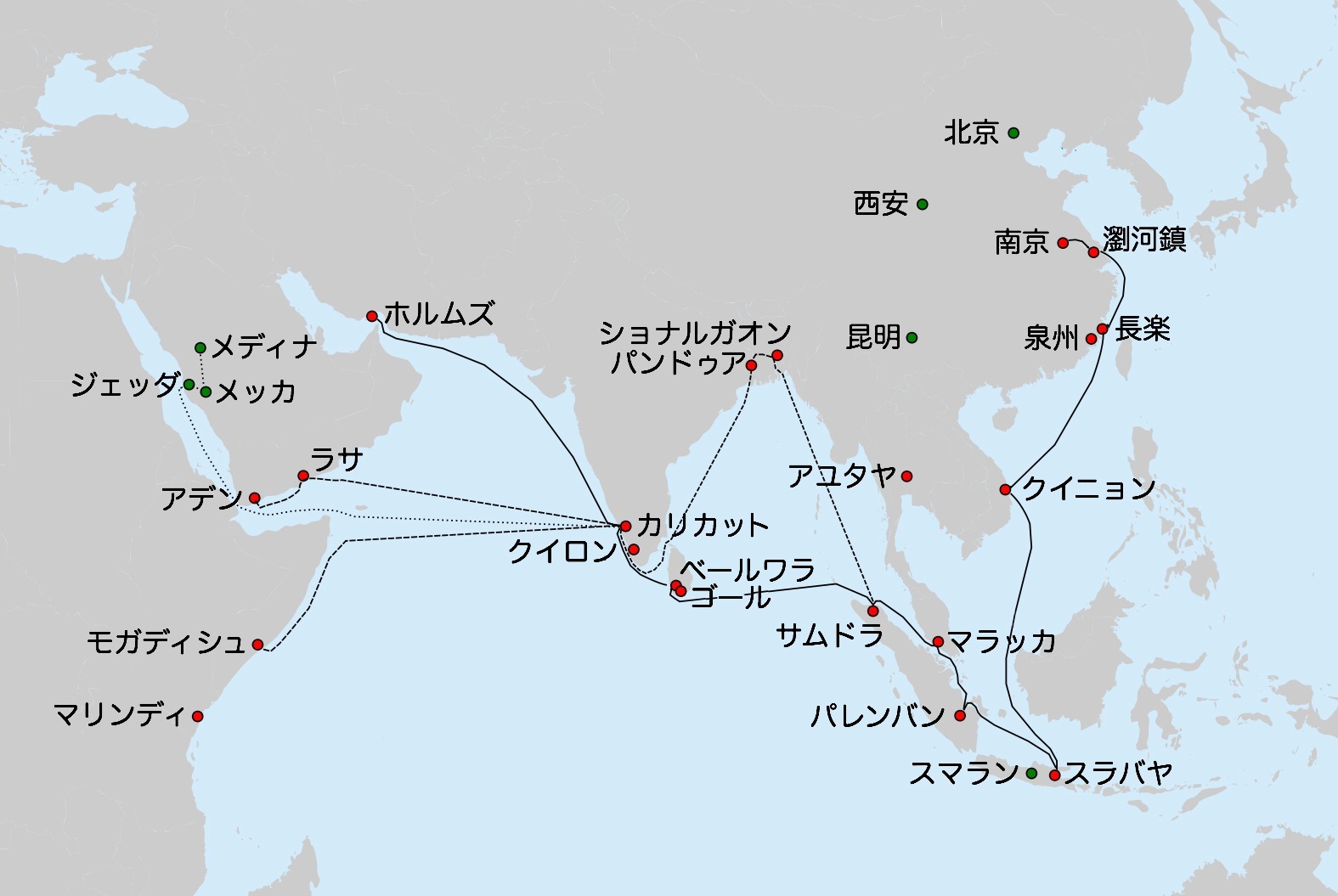
Deutsch: Route der 7. Expedition der Schatzschiffe von Zheng He (1431-1433).
English: Route of the 7th expedition of Zheng He's fleet (1431-1433).
The main source for all routes: chapter on the last expedition of Zheng He in: Dreyer E. L., Zheng He: China and the Oceans in the Early Ming Dynasty, 1405-1433. — Longman, 2007. — 256 p. — (Library of World Biography Series). — ISBN 0321084438. The cities in Bengal are given as per : Barbosa, Duarte & Dames, Mansel Longworth (1996), An Account Of The Countries Bordering On The Indian Ocean And Their Inhabitants; Written By Duarte Barbosa And Completed About The Year 1518 A.D. Vol 1: Including The Coasts Of East Africa, Arabia, Persia And Western India As Far As The Kingdom Of Vijayanagar. Vol. Ii: Including The Coasts Of Malabar, Eastern India, Further India, China And The Indian Archipelago., Asian Educational Services, pp. 138-139, ISBN 8120604512Русский: Маршрут 7-го плавания китайского флота под общим командованием Чжэн Хэ и Ван Цзинхуна (1431-1433 гг). Сплошная линия путь главного флота из Китая в Ормуз (известена достаточно достоверно); прерывистая - эскадра Хун Бао (предположительно); пунктир - путь 7 китайцев (включая Ма Хуаня) из Каликута в Мекку и Медину |
||
| Date | |||
| Source | |||
| Author | Originally by Vmenkov on 2010-08-24, based on the blank map File:Asie.svg (ver. 1) by User:Historicair | ||
| Permission (Reusing this file) |
I, the copyright holder of this work, hereby publish it under the following licenses: This file is licensed under the Creative Commons Attribution-Share Alike 3.0 Unported license.
You may select the license of your choice. |
||
| Other versions |
|


File history
Click on a date/time to view the file as it appeared at that time.
| Date/Time | Thumbnail | Dimensions | User | Comment | |
|---|---|---|---|---|---|
| current | 15:25, 31 May 2011 | | 1,575 × 1,055 (186 KB) | 白拍子花子 (talk | contribs) | cropped |
| 15:16, 31 May 2011 |  | 1,676 × 1,064 (496 KB) | 白拍子花子 (talk | contribs) | == Summary == {{Information |Description= {{de|1=Route der 7. Expedition der Schatzschiffe von Zheng He (1431-1433). * Durchgezogene Linie: die Route der Hauptflotte von Nanjing nach Hormuz, wie in Xia Xiyang (下西洋) beschrieben. * Strichlinie: eine m |
You cannot overwrite this file.
File usage on Commons
There are no pages that use this file.