File:The air quality of London.jpg

Original file (3,508 × 2,480 pixels, file size: 3.99 MB, MIME type: image/jpeg)
Captions
Captions
Summary
edit
| Description |
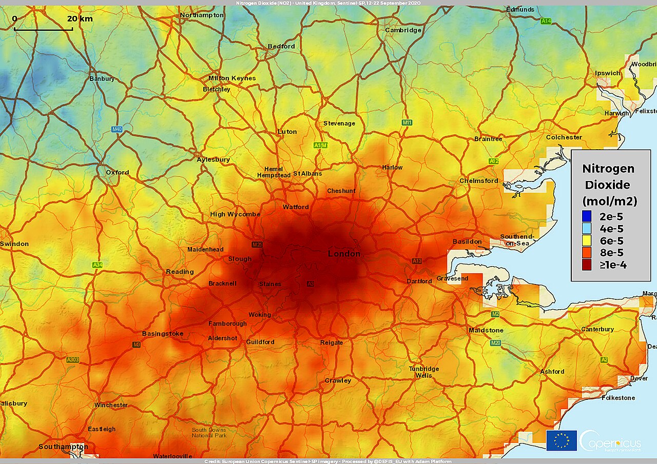
English: According to a recent study published by the European Public Health Alliance (EPHA), the health sector costs of air pollution from roads are higher in London than in any other city in Europe. The research analysed the Eurostat pollution and demographic data from 2018 and WHO recommendations over an unprecedented number of sites across 30 different countries, namely the EU27, the UK, Norway, and Switzerland. The research quantifies the monetary value of premature death, hospital treatment, lost working days and other health costs caused by particulate matter, ozone and nitrogen dioxide. Diesel vehicles are one of the main contributors to the atmospheric pollution as they are the primary source of nitrogen dioxide (NO2) in the air. In conjunction with particulate matter and ground-level ozone (O3), nitrogen dioxide is responsible for nearly 500,000 premature deaths across Europe every year. This explains why the pollution level, combined with the size of the city, is a key factor in contributing to total healthcare costs. The study highlights that London, in particular, suffers from the highest social healthcare costs, at € 11,44bn a year, well ahead of other European cities such as Bucharest (€6.38bn), Berlin (€5.27bn), Warsaw (€4.25bn), Rome (€4.17bn), and Paris (€3.53bn). This map has been obtained by computing the average atmospheric concentration of nitrogen dioxide in the NO2 measurements provided by the Copernicus Sentinel-5P mission from 12 to 22 September 2020. The image shows this distribution over a large area of southern England, visually centered in the city of London. Nitrogen Dioxide is an important atmospheric pollutant affecting air quality: detailed and continuous observations of NO2 are necessary to better assess its impact on climate and atmospheric pollution. The TROPOspheric Monitoring Instrument (TROPOMI) onboard the Copernicus Sentinel-5P satellite allows daily measurements of NO2 levels with an unprecedented level of detail on a global scale. |
| Date | 22 October 2020 (upload date) |
| Source | The air quality of London |
| Author | European Union , Copernicus Sentinel-5P imagery |
Licensing
edit

|
This image contains data from a satellite in the Copernicus Programme, such as Sentinel-1, Sentinel-2 or Sentinel-3. Attribution is required when using this image.
Attribution: Contains modified Copernicus Sentinel data 2020
The use of Copernicus Sentinel Data is regulated under EU law (Commission Delegated Regulation (EU) No 1159/2013 and Regulation (EU) No 377/2014). Relevant excerpts:
Free access shall be given to GMES dedicated data [...] made available through GMES dissemination platforms [...].
Access to GMES dedicated data [...] shall be given for the purpose of the following use in so far as it is lawful:
GMES dedicated data [...] may be used worldwide without limitations in time.
GMES dedicated data and GMES service information are provided to users without any express or implied warranty, including as regards quality and suitability for any purpose. |
File history
Click on a date/time to view the file as it appeared at that time.
| Date/Time | Thumbnail | Dimensions | User | Comment | |
|---|---|---|---|---|---|
| current | 13:17, 9 August 2023 | | 3,508 × 2,480 (3.99 MB) | OptimusPrimeBot (talk | contribs) | #Spacemedia - Upload of https://www.copernicus.eu/system/files/2020-10/image_day/London.jpg via Commons:Spacemedia |
You cannot overwrite this file.
File usage on Commons
There are no pages that use this file.