File:The battle of the Atlantic 1941 map-fr.svg

Original file (SVG file, nominally 1,447 × 1,990 pixels, file size: 411 KB)
Captions
Captions
Summary edit
| Description |
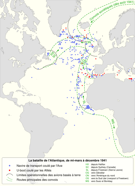
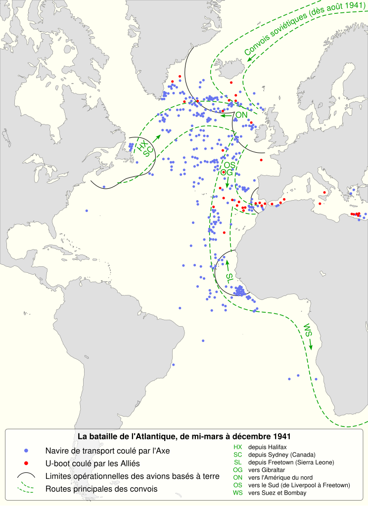
English: The battle of the Atlantic, mid-march to december 1941. In the latter part of April, sweeps and searches replaced close escort. In May 1941 these extends 350 miles from Iceland and Northern Ireland.
Français : La bataille de l'Atlantique, entre la mi-mars et décembre 1941. À partir de fin avril, les recherches aériennes de sous-marins remplacent les escortes rapprochées. En mai 1941, ces recherches s'étendent à 350 miles (~ 560 kilomètres) de l'Islande et l'Irlande du Nord.
|
||
| Date | (UTC) | ||
| Source |
Own work. Source :
|
||
| Author | Sémhur (talk) | ||
| Other versions |
Derivative works of this file: | ||
| Attribution (required by the license) | © Sémhur / Wikimedia Commons / | ||
| SVG | W3C-validity not checked.
|
||
| Graphic Lab |

_-_German_submarines_lost-fr.svg)
| Camera location | | View this and other nearby images on: OpenStreetMap |
|---|
Licensing edit
| Copyleft: This work of art is free; you can redistribute it and/or modify it according to terms of the Free Art License. You will find a specimen of this license on the Copyleft Attitude site as well as on other sites. |
- You are free:
- to share – to copy, distribute and transmit the work
- to remix – to adapt the work
- Under the following conditions:
- attribution – You must give appropriate credit, provide a link to the license, and indicate if changes were made. You may do so in any reasonable manner, but not in any way that suggests the licensor endorses you or your use.
- share alike – If you remix, transform, or build upon the material, you must distribute your contributions under the same or compatible license as the original.
Original upload log edit
This image is a derivative work of the following images:
- File:Convoy_routes_1941.jpg licensed with PD-UKGov
- 2009-03-26T15:41:23Z Gonzosft 800x1314 (242200 Bytes) {{Information |Description={{en|1=THE BATTLE OF THE ATLANTIC (III), MID-MARCH–DECEMBER 1941}} |Source=http://www.archive.org/index.php |Author=Dennis Richards, HMSO, LONDON |Date=1953 |Permission={{PD-BritishGov}} |other
Uploaded with derivativeFX
File history
Click on a date/time to view the file as it appeared at that time.
| Date/Time | Thumbnail | Dimensions | User | Comment | |
|---|---|---|---|---|---|
| current | 10:58, 7 October 2020 | | 1,447 × 1,990 (411 KB) | Msmazores2019 (talk | contribs) | File uploaded using svgtranslate tool (https://svgtranslate.toolforge.org/). Added translation for pt. |
| 07:53, 17 October 2011 |  | 1,447 × 1,990 (447 KB) | Sémhur (talk | contribs) | Modification d'un texte de légende | |
| 17:46, 13 October 2011 |  | 1,447 × 1,990 (402 KB) | Sémhur (talk | contribs) | Precision | |
| 19:55, 12 October 2011 |  | 1,447 × 1,990 (393 KB) | Sémhur (talk | contribs) | Correct size | |
| 19:49, 12 October 2011 |  | 512 × 704 (389 KB) | Sémhur (talk | contribs) | == {{int:filedesc}} == {{Information |Description={{Multilingual description |en= The battle of the Atlantic, mid-march to december 1941.<br> In the latter part of April, sweeps and searches replaced close esco |
You cannot overwrite this file.
File usage on Commons
The following 5 pages use this file:
File usage on other wikis
The following other wikis use this file:
- Usage on fr.wikipedia.org
- Usage on ja.wikipedia.org