File:The village of Mundesley - geograph.org.uk - 968098.jpg
No higher resolution available.
The_village_of_Mundesley_-_geograph.org.uk_-_968098.jpg (640 × 480 pixels, file size: 126 KB, MIME type: image/jpeg)
Captions
Captions
Add a one-line explanation of what this file represents
Summary
edit
| Description |
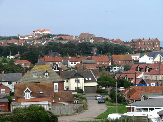
English: The village of Mundesley. This view was taken in northwesterly direction, diagonally across the grid square. The red-brick building seen in mid-distance (at right) is the Manor Hotel > 968084. In the background (centre) the church of All Saints can be seen > 967818 - 967827. The building glimpsed on the horizon (at left, in adjacent grid square), located high above the village, is Trafalgar Court > 527300.
When the railway opened in 1889 - bringing visitors wishing to sample the fresh sea air - the village of Mundesley grew rapidly. The railway is now long gone but Mundesley is still considered to be one of the best a holiday resorts in Norfolk, offering a sandy beach with safe swimming for children when the tide is out; the East Norfolk Coast Path/Peddars Way follows the coastline and offers splendid views across the North Sea. Properties date mainly from Victorian times and many houses are constructed from traditional Norfolk materials such as flint and brick, with thatch or pantile roofs. The village contains a small number of shops, eating places, pubs, tea rooms and possibly the smallest museum in the country, the Maritime Museum > https://www.geograph.org.uk/photo/204932. Several holiday parks are in the vicinity of the village, the largest one being Mundesley Holiday Village, located a short distance to the southeast. |
| Date | Taken on 18 September 2008 |
| Source | From geograph.org.uk |
| Author | Evelyn Simak |
| Attribution (required by the license) | Evelyn Simak / The village of Mundesley / |
| Camera location | | View this and other nearby images on: OpenStreetMap |
|---|
_heading:315.00&language=en)
| Object location | | View this and other nearby images on: OpenStreetMap |
|---|
_heading:315.00&language=en)
Licensing
edit

|
This image was taken from the Geograph project collection. See this photograph's page on the Geograph website for the photographer's contact details. The copyright on this image is owned by Evelyn Simak and is licensed for reuse under the Creative Commons Attribution-ShareAlike 2.0 license.
|
This file is licensed under the Creative Commons Attribution-Share Alike 2.0 Generic license.
Attribution: Evelyn Simak
- You are free:
- to share – to copy, distribute and transmit the work
- to remix – to adapt the work
- Under the following conditions:
- attribution – You must give appropriate credit, provide a link to the license, and indicate if changes were made. You may do so in any reasonable manner, but not in any way that suggests the licensor endorses you or your use.
- share alike – If you remix, transform, or build upon the material, you must distribute your contributions under the same or compatible license as the original.
File history
Click on a date/time to view the file as it appeared at that time.
| Date/Time | Thumbnail | Dimensions | User | Comment | |
|---|---|---|---|---|---|
| current | 18:26, 22 February 2011 | | 640 × 480 (126 KB) | GeographBot (talk | contribs) | == {{int:filedesc}} == {{Information |description={{en|1=The village of Mundesley This view was taken in northwesterly direction, diagonally across the grid square. The red-brick building seen in mid-distance (at right) is the Manor Hotel > http://www.geo |
You cannot overwrite this file.
File usage on Commons
There are no pages that use this file.