File:Thessaloniki historic city centre.svg

Size of this PNG preview of this SVG file: 462 × 600 pixels. Other resolutions: 185 × 240 pixels | 370 × 480 pixels | 592 × 768 pixels | 789 × 1,024 pixels | 1,578 × 2,048 pixels | 1,456 × 1,890 pixels.
Original file (SVG file, nominally 1,456 × 1,890 pixels, file size: 2.42 MB)
Captions
Captions
Add a one-line explanation of what this file represents
Summary
edit| Description |
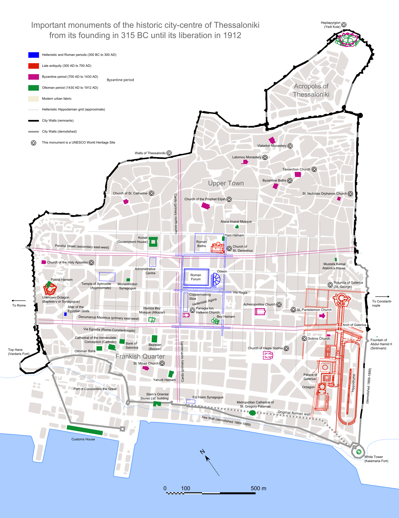
English: A map showing the historic city centre of Thessaloniki, with important buildings of various periods. This file was derived from: Thessaloniki historical center el.svg by original authorBadseed . Other sources used: For the location of the Etz Haim synagogue and the Baptestry/Synagogue, for the Hippodamian grid and other Hellenistic structures, for the map of Top Hane and the harbour walls, for the layout of medieval Thessaloniki, for the layout of the Galerian complex (complete map outside bounding box of PDF), for the accurate mapping of the city walls. |
| Date | |
| Source | Own work |
| Author | Philly boy92 |
| Other versions |
[]
|


Licensing
edit
I, the copyright holder of this work, hereby publish it under the following license:
This file is licensed under the Creative Commons Attribution-Share Alike 4.0 International license.
- You are free:
- to share – to copy, distribute and transmit the work
- to remix – to adapt the work
- Under the following conditions:
- attribution – You must give appropriate credit, provide a link to the license, and indicate if changes were made. You may do so in any reasonable manner, but not in any way that suggests the licensor endorses you or your use.
- share alike – If you remix, transform, or build upon the material, you must distribute your contributions under the same or compatible license as the original.
File history
Click on a date/time to view the file as it appeared at that time.
| Date/Time | Thumbnail | Dimensions | User | Comment | |
|---|---|---|---|---|---|
| current | 17:20, 27 September 2018 | | 1,456 × 1,890 (2.42 MB) | Sarah fides (talk | contribs) | Date correction for Ottoman period, change of colour to the modern city, doubled in size to make writing clear when viewed at 100% as an svg, Roman wall text rasterised |
| 16:30, 17 September 2018 |  | 723 × 944 (2.32 MB) | Sarah fides (talk | contribs) | Better sea walls | |
| 11:19, 15 September 2018 |  | 723 × 944 (2.32 MB) | Sarah fides (talk | contribs) | More accurate version of the city walls and the Hippodamian grid | |
| 18:40, 13 September 2018 |  | 723 × 944 (2.33 MB) | Sarah fides (talk | contribs) | White background | |
| 18:33, 13 September 2018 |  | 723 × 944 (2.33 MB) | Sarah fides (talk | contribs) | Added some more monuments | |
| 19:31, 12 September 2018 |  | 723 × 944 (2.25 MB) | Sarah fides (talk | contribs) | Hippodamian grid, location of administrative centre, altar of the egyptian gods | |
| 15:43, 12 September 2018 |  | 723 × 944 (2.18 MB) | Sarah fides (talk | contribs) | User created page with UploadWizard |
You cannot overwrite this file.
File usage on Commons
The following 8 pages use this file:
- File:Thessaloniki historic city centre.svg
- File:Thessaloniki historical center.svg
- File:Thessaloniki historical center el.svg
- File:Thessaloniki historical center el2.png
- File:Thessaloniki historical center es.svg
- File:Thessaloniki historical center mk.svg
- File:Thessaloniki historical center uk.svg
- Template:Other versions/Thessaloniki historical center
File usage on other wikis
The following other wikis use this file:
- Usage on en.wikipedia.org
- Usage on pl.wikipedia.org