File:Thiên Nam tứ chí lộ đồ thư.jpg

Size of this preview: 800 × 335 pixels. Other resolutions: 320 × 134 pixels | 640 × 268 pixels | 1,470 × 615 pixels.
Original file (1,470 × 615 pixels, file size: 507 KB, MIME type: image/jpeg)
Captions
Captions
Add a one-line explanation of what this file represents
Summary
edit
| Description |
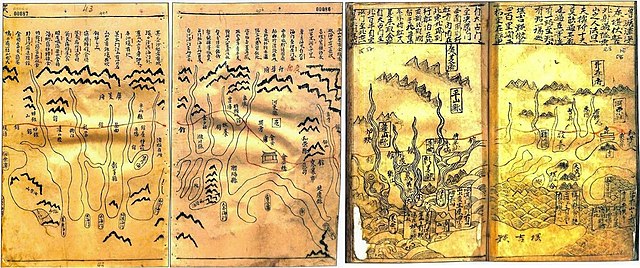
Tiếng Việt: Đây là bản đồ vùng Quảng Ngãi và quần đảo Hoàng Sa, trong tập bản đồ Thiên Nam tứ chí lộ đồ thư do Đỗ Bá biên soạn vào giữa thế kỷ XVII. |
| Date | 17th century |
| Source | http://biengioilanhtho.gov.vn/Media/bbg/image/T%C6%B0%20li%E1%BB%87u%20l%E1%BB%8Bch%20s%E1%BB%AD/ban%20do%20Do%20Ba(1).jpg |
| Author | Đỗ Bá Công |
.jpg)
Licensing
edit
|
This work is in the public domain in its country of origin and other countries and areas where the copyright term is the author's life plus 70 years or fewer. | |
| This file has been identified as being free of known restrictions under copyright law, including all related and neighboring rights. | |
File history
Click on a date/time to view the file as it appeared at that time.
| Date/Time | Thumbnail | Dimensions | User | Comment | |
|---|---|---|---|---|---|
| current | 04:45, 18 May 2022 | | 1,470 × 615 (507 KB) | Doãn Hiệu (talk | contribs) | Thêm phiên bản gốc của Thiên Nam tứ chí lộ đồ thư (bản đồ xứ Quảng Nam) có chú dẫn miêu tả Bãi Cát Vàng. Các phiên bản trước kia của tập tin này là bản đồ xứ Quảng của Toản tập An Nam lộ cũng do Đỗ Bá Công Đạo soạn. |
| 23:28, 16 May 2022 |  | 689 × 617 (185 KB) | Doãn Hiệu (talk | contribs) | tải lên bản gốc. | |
| 00:32, 17 April 2012 |  | 750 × 734 (413 KB) | Thần y (talk | contribs) |
You cannot overwrite this file.
File usage on Commons
There are no pages that use this file.
File usage on other wikis
The following other wikis use this file:
- Usage on en.wikipedia.org
- Usage on vi.wikipedia.org
- Usage on za.wikipedia.org
- Usage on zh.wikipedia.org