File:Thick Ice in the Baltic Sea 2010-03-05 lrg.jpg

Size of this preview: 800 × 600 pixels. Other resolutions: 320 × 240 pixels | 640 × 480 pixels | 1,024 × 768 pixels | 1,280 × 960 pixels | 2,560 × 1,920 pixels | 3,840 × 2,880 pixels.
Original file (3,840 × 2,880 pixels, file size: 3.63 MB, MIME type: image/jpeg)
Captions
Captions
Add a one-line explanation of what this file represents
Summary
edit| Description |
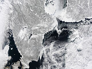
English: Enough ice lines the coasts of Sweden (left) and Finland (right) in this natural-color image that it is difficult to tell where the coasts end and the sea begins. The sea ice envelops the islands that line this part of the coast, joining them to the shore. Only the sheltered water near Stockholm is partly free of ice. Dark water contrasts with the surrounding field of white snow and ice. Away from the coast, the Baltic Sea is sprinkled with bits of sea ice. A thin layer of clouds stretches over part of the scene, but the brighter ice is still visible beneath the clouds.
The Moderate Resolution Imaging Spectroradiometer (MODIS) on NASA’s Terra satellite captured this true-color image on March 5, 2010. |
| Date | |
| Source | http://earthobservatory.nasa.gov/NaturalHazards/view.php?id=43048&src=nha |
| Author | NASA |
| Other versions |
|

Licensing
edit
| This file is in the public domain in the United States because it was solely created by NASA. NASA copyright policy states that "NASA material is not protected by copyright unless noted". (See Template:PD-USGov, NASA copyright policy page or JPL Image Use Policy.) | ||
 |
Warnings:
|
File history
Click on a date/time to view the file as it appeared at that time.
| Date/Time | Thumbnail | Dimensions | User | Comment | |
|---|---|---|---|---|---|
| current | 20:20, 8 March 2010 | | 3,840 × 2,880 (3.63 MB) | Captain-tucker (talk | contribs) | {{Information |Description={{en|Enough ice lines the coasts of Sweden (left) and Finland (right) in this natural-color image that it is difficult to tell where the coast ends and the sea begins. The sea ice envelops the islands that line this part of the |
You cannot overwrite this file.
File usage on Commons
The following page uses this file: