File:Thirteen Colonies 1775 map-es.svg

Size of this PNG preview of this SVG file: 327 × 599 pixels. Other resolutions: 131 × 240 pixels | 262 × 480 pixels | 419 × 768 pixels | 559 × 1,024 pixels | 1,118 × 2,048 pixels | 520 × 952 pixels.
Original file (SVG file, nominally 520 × 952 pixels, file size: 151 KB)
Captions
Captions
Add a one-line explanation of what this file represents
Summary edit
| Description |
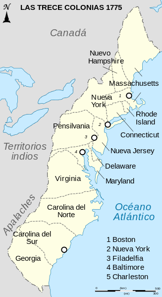
English: Map of the Thirteen British Colonies in North America around 1775, before independence.
Español: Mapa de las Trece Colonias de Norteamérica en 1775, antes de su independencia de Gran Bretaña.
Français : Carte des Treize Colonies britanniques d'Amérique du Nord vers 1775, avant leur indépendance. |
| Date | (UTC) |
| Source |
This file was derived from: Thirteen Colonies 1775 map-fr.svg:  |
| Author |
|
| Other versions |
|


| This is a retouched picture, which means that it has been digitally altered from its original version. Modifications: translated into Spanish. The original can be viewed here: Thirteen Colonies 1775 map-fr.svg:
|
Licensing edit
This file is licensed under the Creative Commons Attribution-Share Alike 3.0 Unported license.
- You are free:
- to share – to copy, distribute and transmit the work
- to remix – to adapt the work
- Under the following conditions:
- attribution – You must give appropriate credit, provide a link to the license, and indicate if changes were made. You may do so in any reasonable manner, but not in any way that suggests the licensor endorses you or your use.
- share alike – If you remix, transform, or build upon the material, you must distribute your contributions under the same or compatible license as the original.
Original upload log edit
This image is a derivative work of the following images:
- File:Thirteen_Colonies_1775_map-fr.svg licensed with Cc-by-sa-3.0,2.5,2.0,1.0, GFDL
- 2009-12-16T16:05:21Z Kmusser 520x952 (154677 Bytes) adjusted NY-NH border to match source image
- 2008-10-09T08:57:39Z Sémhur 520x952 (153826 Bytes) {{Information |Description={{en|1=Map of the Thirteen British Colonies in North America around 1775, before independence.}} {{fr|1=Carte des Treize Colonies britanniques d'Amérique du Nord vers 1775, avant leur indépendance
Uploaded with derivativeFX
File history
Click on a date/time to view the file as it appeared at that time.
| Date/Time | Thumbnail | Dimensions | User | Comment | |
|---|---|---|---|---|---|
| current | 20:08, 23 April 2013 | | 520 × 952 (151 KB) | Rowanwindwhistler (talk | contribs) | == {{int:filedesc}} == {{Information |Description={{en|1=Map of the Thirteen British Colonies in North America around 1775, before independence.}} {{es|1=Mapa de las Trece Colonias de Norteamérica en 1775, antes de su independencia de Gran Bretaña.}}... |
You cannot overwrite this file.
File usage on Commons
The following 3 pages use this file:
File usage on other wikis
The following other wikis use this file:
- Usage on it.wikipedia.org