File:Three rivers (2548612404).jpg

Size of this preview: 800 × 596 pixels. Other resolutions: 320 × 239 pixels | 640 × 477 pixels | 1,024 × 763 pixels | 1,280 × 954 pixels | 1,984 × 1,479 pixels.
Original file (1,984 × 1,479 pixels, file size: 686 KB, MIME type: image/jpeg)
Captions
Captions
Add a one-line explanation of what this file represents
Summary
edit.jpg&action=edit§ion=1)
| Description |
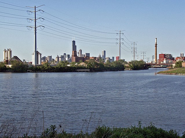
The confluence that made Chicago. The Sanitary & Ship Canal [originally I&M Canal] (left) created a water route enabling ships to travel between the Great Lakes (and Hudson Valley via Erie Canal) and Mississippi basins. The South Branch of the Chicago River (to upper right) created the Lake Michigan harbor upon which Fort Dearborn was built. Bubbly Creek (lower right) drained the stockyards. View from Canal Origins Park |
| Date | |
| Source | Three rivers |
| Author | Payton Chung from DCA, USA |
| Camera location | | View this and other nearby images on: OpenStreetMap |
|---|
.jpg¶ms=041.842902_N_-087.665405_E_globe:Earth_type:camera_source:Flickr_&language=en)
Licensing
edit.jpg&action=edit§ion=2)
This file is licensed under the Creative Commons Attribution 2.0 Generic license.
- You are free:
- to share – to copy, distribute and transmit the work
- to remix – to adapt the work
- Under the following conditions:
- attribution – You must give appropriate credit, provide a link to the license, and indicate if changes were made. You may do so in any reasonable manner, but not in any way that suggests the licensor endorses you or your use.
| This image was originally posted to Flickr by Payton Chung at https://flickr.com/photos/41813589@N00/2548612404. It was reviewed on 1 January 2017 by FlickreviewR and was confirmed to be licensed under the terms of the cc-by-2.0. |
File history
Click on a date/time to view the file as it appeared at that time.
| Date/Time | Thumbnail | Dimensions | User | Comment | |
|---|---|---|---|---|---|
| current | 01:35, 1 January 2017 | | 1,984 × 1,479 (686 KB) | Victorgrigas (talk | contribs) | Transferred from Flickr via Flickr2Commons |
You cannot overwrite this file.
File usage on Commons
There are no pages that use this file.
.jpg&oldid=783061256)