File:Thunderstorm, Texas Gulf Coast, USA photographed during STS-31.jpg

Size of this preview: 600 × 600 pixels. Other resolutions: 240 × 240 pixels | 480 × 480 pixels | 768 × 768 pixels | 1,024 × 1,024 pixels | 2,048 × 2,048 pixels | 5,699 × 5,699 pixels.
Original file (5,699 × 5,699 pixels, file size: 4.6 MB, MIME type: image/jpeg)
Captions
Captions
Thunderstorm, Texas Gulf Coast, USA photographed during STS-31
Summary
edit
| Description |
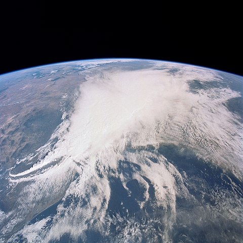
English: STS031-77-078 - This thunderstorm along the Texas Gulf Coast (29.0N, 95.0W), USA is seen as the trailing edge of a large cloud mass formed along the leading edge of a spring frontal system stretching northwest to southeast across the Texas Gulf Coast. This system brought extensive severe weather and flooding to parts of Texas and surrounding states. Muddy water discharging from coastal streams can be seen in the shallow Gulf of Mexico as far south as Lavaca Bay. |
| Date | |
| Source | NASA Image and Video Library JSC Gateway to Astronaut Photography of Earth |
| Author | NASA |
| Camera location | | View this and other nearby images on: OpenStreetMap |
|---|
This image or video was catalogued by Johnson Space Center of the United States National Aeronautics and Space Administration (NASA) under Photo ID: s31-77-078 and Alternate ID: STS031-77-078. This tag does not indicate the copyright status of the attached work. A normal copyright tag is still required. See Commons:Licensing. Other languages:
|
Licensing
edit
| This file is in the public domain in the United States because it was solely created by NASA. NASA copyright policy states that "NASA material is not protected by copyright unless noted". (See Template:PD-USGov, NASA copyright policy page or JPL Image Use Policy.) | ||
 |
Warnings:
|
File history
Click on a date/time to view the file as it appeared at that time.
| Date/Time | Thumbnail | Dimensions | User | Comment | |
|---|---|---|---|---|---|
| current | 20:29, 12 January 2021 | | 5,699 × 5,699 (4.6 MB) | Askeuhd (talk | contribs) | Uploaded a work by NASA from [https://images.nasa.gov/ NASA Image and Video Library] with UploadWizard |
You cannot overwrite this file.
File usage on Commons
There are no pages that use this file.