File:Thuringia relief location map (Eic-Landkreise 2017).jpg
No higher resolution available.
Thuringia_relief_location_map_(Eic-Landkreise_2017).jpg (482 × 523 pixels, file size: 157 KB, MIME type: image/jpeg)
Captions
Captions
Add a one-line explanation of what this file represents
Summary edit
.jpg&action=edit§ion=1)
| Description |
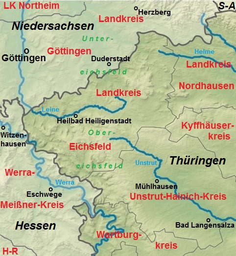
Deutsch: Verwaltungsgliederung des Eichsfeldes und der benachbarten Regionen im Jahr 2017 (es fehlt noch der LK Northeim) |
| Date | |
| Source | Own work |
| Author | 79.214er |
| Other versions |
This file was derived from: Thuringia relief location map.jpg |
Licensing edit
.jpg&action=edit§ion=2)
I, the copyright holder of this work, hereby publish it under the following license:
This file is licensed under the Creative Commons Attribution-Share Alike 4.0 International license.
- You are free:
- to share – to copy, distribute and transmit the work
- to remix – to adapt the work
- Under the following conditions:
- attribution – You must give appropriate credit, provide a link to the license, and indicate if changes were made. You may do so in any reasonable manner, but not in any way that suggests the licensor endorses you or your use.
- share alike – If you remix, transform, or build upon the material, you must distribute your contributions under the same or compatible license as the original.
File history
Click on a date/time to view the file as it appeared at that time.
| Date/Time | Thumbnail | Dimensions | User | Comment | |
|---|---|---|---|---|---|
| current | 08:21, 6 April 2017 | | 482 × 523 (157 KB) | 79.214er (talk | contribs) | Landkreise ergänzt |
| 14:56, 5 April 2017 |  | 482 × 523 (153 KB) | 79.214er (talk | contribs) | User created page with UploadWizard |
You cannot overwrite this file.
File usage on Commons
The following 2 pages use this file:
.jpg&oldid=475403452)