File:Tianjin metro outline.svg

Size of this PNG preview of this SVG file: 800 × 480 pixels. Other resolutions: 320 × 192 pixels | 1,024 × 614 pixels | 1,280 × 768 pixels | 2,560 × 1,536 pixels.
Original file (SVG file, nominally 1,000 × 600 pixels, file size: 96 KB)
Captions
Captions
Add a one-line explanation of what this file represents
Summary
edit
| Description |
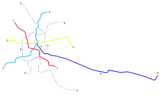
English: This is a map of Tianjin Metro system drawn to scale. The lines shown in this map are currently in operation or under construction. TEDA Tram is excluded.
中文(简体):这是按照实际比例绘制的天津轨道交通线路图。该图中的线路目前在运营中或正在施工中。泰达导轨线路未绘制。 |
| Date | |
| Source | Own work |
| Author | Kuailong |
| Other versions | Derivative works of this file: Tianjin metro outline-2.svg |
Licensing
edit
I, the copyright holder of this work, hereby publish it under the following license:
This file is licensed under the Creative Commons Attribution-Share Alike 3.0 Unported license.
- You are free:
- to share – to copy, distribute and transmit the work
- to remix – to adapt the work
- Under the following conditions:
- attribution – You must give appropriate credit, provide a link to the license, and indicate if changes were made. You may do so in any reasonable manner, but not in any way that suggests the licensor endorses you or your use.
- share alike – If you remix, transform, or build upon the material, you must distribute your contributions under the same or compatible license as the original.
File history
Click on a date/time to view the file as it appeared at that time.
| Date/Time | Thumbnail | Dimensions | User | Comment | |
|---|---|---|---|---|---|
| current | 17:25, 3 September 2014 | | 1,000 × 600 (96 KB) | Kuailong (talk | contribs) | Binhai Int'l Airport station in now in service. |
| 05:53, 3 June 2014 |  | 1,000 × 600 (96 KB) | Kuailong (talk | contribs) | Even more twerks | |
| 02:57, 3 June 2014 |  | 1,000 × 600 (108 KB) | Kuailong (talk | contribs) | more twerks | |
| 02:46, 3 June 2014 |  | 1,000 × 600 (107 KB) | Kuailong (talk | contribs) | Update: new stations open in Line 2 & 3. Improve readability. (inspired by User:Pechristener) | |
| 11:31, 23 April 2013 |  | 1,000 × 600 (92 KB) | Kuailong (talk | contribs) | {{Information |Description ={{en|1=This is a map of Tianjin Metro system drawn to scale. The lines shown in this map are currently in operation or under construction. TEDA Tram is excluded.}} {{zh-hans|1=这是按照实际比例绘制的天津轨道... |
You cannot overwrite this file.
File usage on Commons
The following page uses this file:
File usage on other wikis
The following other wikis use this file:
- Usage on cs.wikipedia.org