File:Tievebulliagh - geograph.org.uk - 472775.jpg
No higher resolution available.
Tievebulliagh_-_geograph.org.uk_-_472775.jpg (640 × 427 pixels, file size: 249 KB, MIME type: image/jpeg)
Captions
Captions
Add a one-line explanation of what this file represents
Summary
edit
| Description |
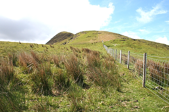
English: Tievebulliagh The distinctively-shaped summit of Tievebulliagh is easy to see from miles around. It is formed from a dolerite plug cutting through the chalk and Lower Basalt. A slab of lateritic rock fell into the magma and was baked hard by the intense heat, forming an extremely hard rock called porcellanite, which was worked in Neolithic times to make axes and other tools. |
| Date | |
| Source | From geograph.org.uk |
| Author | Anne Burgess |
| Attribution (required by the license) | Anne Burgess / Tievebulliagh / |
| Camera location | | View this and other nearby images on: OpenStreetMap |
|---|
_heading:202.00&language=en)
| Object location | | View this and other nearby images on: OpenStreetMap |
|---|
_heading:202.00&language=en)
Licensing
edit

|
This image was taken from the Geograph project collection. See this photograph's page on the Geograph website for the photographer's contact details. The copyright on this image is owned by Anne Burgess and is licensed for reuse under the Creative Commons Attribution-ShareAlike 2.0 license.
|
This file is licensed under the Creative Commons Attribution-Share Alike 2.0 Generic license.
Attribution: Anne Burgess
- You are free:
- to share – to copy, distribute and transmit the work
- to remix – to adapt the work
- Under the following conditions:
- attribution – You must give appropriate credit, provide a link to the license, and indicate if changes were made. You may do so in any reasonable manner, but not in any way that suggests the licensor endorses you or your use.
- share alike – If you remix, transform, or build upon the material, you must distribute your contributions under the same or compatible license as the original.
File history
Click on a date/time to view the file as it appeared at that time.
| Date/Time | Thumbnail | Dimensions | User | Comment | |
|---|---|---|---|---|---|
| current | 23:44, 4 February 2011 | | 640 × 427 (249 KB) | GeographBot (talk | contribs) | == {{int:filedesc}} == {{Information |description={{en|1=Tievebulliagh The distinctively-shaped summit of Tievebulliagh is easy to see from miles around. It is formed from a dolerite plug cutting through the chalk and Lower Basalt. A slab of lateritic roc |
You cannot overwrite this file.
File usage on Commons
There are no pages that use this file.