File:Tionesta Lake.jpg

Size of this preview: 800 × 533 pixels. Other resolutions: 320 × 213 pixels | 640 × 426 pixels | 1,024 × 682 pixels.
Original file (1,024 × 682 pixels, file size: 357 KB, MIME type: image/jpeg)
Captions
Captions
Add a one-line explanation of what this file represents
| Camera location | | View this and other nearby images on: OpenStreetMap |
|---|
| Description |
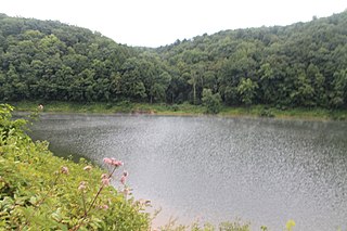
English: Overview of Tionesta Lake, formed by damming Tionesta Creek just above its confluence with the Allegheny River in Tionesta Township, Forest County, Pennsylvania, United States. |
| Date | |
| Source | Flickr |
| Author | Andy Arthur |
| Permission (Reusing this file) |
This file is licensed under the Creative Commons Attribution 2.0 Generic license.
|
| This image was originally posted to Flickr by andyarthur at https://www.flickr.com/photos/45846171@N04/7707115648. It was reviewed on 23 April 2015 by FlickreviewR and was confirmed to be licensed under the terms of the cc-by-2.0. |
File history
Click on a date/time to view the file as it appeared at that time.
| Date/Time | Thumbnail | Dimensions | User | Comment | |
|---|---|---|---|---|---|
| current | 22:36, 23 April 2015 | | 1,024 × 682 (357 KB) | Nyttend (talk | contribs) | {{Location|41|28|24|N|79|26|22|W}} {{Information |Description={{en|Overview of {{w|Tionesta Lake}}, formed by damming {{w|Tionesta Creek}} just above its confluence with the {{w|Allegheny River}} in {{w|Tionesta Township, Forest County, Pennsylvania|Ti... |
You cannot overwrite this file.
File usage on Commons
The following page uses this file:
File usage on other wikis
The following other wikis use this file:
- Usage on cy.wikipedia.org
- Usage on en.wikipedia.org
- Usage on es.wikipedia.org
- Usage on fr.wikipedia.org
- Usage on tl.wikipedia.org
- Usage on uk.wikipedia.org
- Usage on vi.wikipedia.org
- Usage on www.wikidata.org