File:Togo location map Topographic.png
Size of this preview: 408 × 600 pixels. Other resolutions: 163 × 240 pixels | 326 × 480 pixels | 717 × 1,054 pixels.
Original file (717 × 1,054 pixels, file size: 1.17 MB, MIME type: image/png)
Captions
Captions
Add a one-line explanation of what this file represents
Summary edit
| Description |
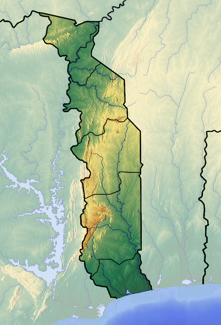
Français : Carte topographique du Togo |
| Date | |
| Source | Own work (backgroung : http://www.maps-for-free.com) |
| Author | Dr Brains |
Licensing edit
I, the copyright holder of this work, hereby publish it under the following licenses:

|
Permission is granted to copy, distribute and/or modify this document under the terms of the GNU Free Documentation License, Version 1.2 only as published by the Free Software Foundation; with no Invariant Sections, no Front-Cover Texts, and no Back-Cover Texts. A copy of the license is included in the section entitled GNU Free Documentation License. | 1.2 only |
|
|
Permission is granted to copy, distribute and/or modify this document under the terms of the GNU Free Documentation License, Version 1.3 or any later version published by the Free Software Foundation; with no Invariant Sections, no Front-Cover Texts, and no Back-Cover Texts. A copy of the license is included in the section entitled GNU Free Documentation License.
|
If this file is eligible for relicensing, it may also be used under the Creative Commons Attribution-ShareAlike 3.0 license. The relicensing status of this image needs to be manually reviewed by an experienced user. You can help.
|
You may select the license of your choice.
File history
Click on a date/time to view the file as it appeared at that time.
| Date/Time | Thumbnail | Dimensions | User | Comment | |
|---|---|---|---|---|---|
| current | 14:04, 26 June 2012 | | 717 × 1,054 (1.17 MB) | Dark Attsios (talk | contribs) | pleine résolution (erreur de ma part) |
| 13:38, 26 June 2012 |  | 408 × 599 (411 KB) | Dark Attsios (talk | contribs) | réajustement de la carte pour concorder avec le fichier svg | |
| 21:27, 11 June 2012 |  | 722 × 1,057 (1.17 MB) | Dr Brains (talk | contribs) |
You cannot overwrite this file.
File usage on Commons
The following 2 pages use this file:
File usage on other wikis
The following other wikis use this file:
- Usage on ar.wikipedia.org
- Usage on ast.wikipedia.org
- Usage on az.wikipedia.org
- Usage on ba.wikipedia.org
- Usage on bcl.wikipedia.org
- Usage on be.wikipedia.org
- Usage on bg.wikipedia.org
- Usage on bn.wikipedia.org
- Usage on bs.wikipedia.org
- Usage on ca.wikipedia.org
- Usage on ceb.wikipedia.org
- Usage on cs.wikipedia.org
- Usage on da.wikipedia.org
- Usage on de.wikipedia.org
- Usage on el.wikipedia.org
- Usage on en.wikipedia.org
- Mount Agou
- Kéran National Park
- Fazao Malfakassa National Park
- Abdoulaye Faunal Reserve
- Module:Location map/data/Togo/doc
- 1963 Togolese coup d'état
- Geology of Togo
- Nangbeto Dam
- Fosse aux Lions National Park
- Module:Location map/data/Togo
- List of fossiliferous stratigraphic units in Togo
- 1967 Togolese coup d'état
- 1986 Togolese coup attempt
- Usage on eo.wikipedia.org
- Usage on fa.wikipedia.org
View more global usage of this file.