File:Tomsk 1898.jpg

Original file (12,788 × 17,281 pixels, file size: 21.29 MB, MIME type: image/jpeg)
Captions
Captions
| Warning | The original file is very high-resolution. It might not load properly or could cause your browser to freeze when opened at full size. |
|---|
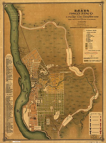
Plan goroda Tomska s prilegaiushchei k nemu zhelieznodorozhnoi vietv'iu. Sostavil: zemlemier Sredne-sib. zh.d. S.A. Syrtsov.
Syrtsov, S. A.
CREATED/PUBLISHED Tomsk, Rossīia, Izd. Tipo-litografīi M.N. Kononova i I.F. Skulimovskago. 1898.
NOTES Scale 1:16,800; [v anglīiskom diuimie] 200 [sazhen]
Relief shown by land form drawings.
Russian.
Shows wards and fire districts.
Includes index to points of interest and col. illus. of fire signals.
CALL NUMBER G7064.T72 1898 .S9
REPOSITORY Library of Congress Geography and Map Division Washington, D.C. 20540-4650 USA
DIGITAL ID g7064t mf000022 http://hdl.loc.gov/loc.gmd/g7064t.mf000022
This media file is in the public domain in the United States. This applies to U.S. works where the copyright has expired, often because its first publication occurred prior to January 1, 1929, and if not then due to lack of notice or renewal. See this page for further explanation.
|
 | |
 |
This image might not be in the public domain outside of the United States; this especially applies in the countries and areas that do not apply the rule of the shorter term for US works, such as Canada, Mainland China (not Hong Kong or Macao), Germany, Mexico, and Switzerland. The creator and year of publication are essential information and must be provided. See Wikipedia:Public domain and Wikipedia:Copyrights for more details.
|

|
This image is available from the United States Library of Congress's Prints and Photographs division
under the digital ID g7064t.mf000022. This tag does not indicate the copyright status of the attached work. A normal copyright tag is still required. See Commons:Licensing.
|
File history
Click on a date/time to view the file as it appeared at that time.
| Date/Time | Thumbnail | Dimensions | User | Comment | |
|---|---|---|---|---|---|
| current | 04:03, 24 April 2014 | | 12,788 × 17,281 (21.29 MB) | Gerodian (talk | contribs) | Нашел версию с более лучшим разрешением. |
| 02:03, 15 August 2007 |  | 6,138 × 8,295 (9.19 MB) | Balcer~commonswiki (talk | contribs) | Plan goroda Tomska s prilegaiushchei k nemu zhelieznodorozhnoi vietv'iu. Sostavil: zemlemier Sredne-sib. zh.d. S.A. Syrtsov. Syrtsov, S. A. CREATED/PUBLISHED Tomsk, Rossīia, Izd. Tipo-litografīi M.N. Kononova i I.F. Skulimovskago. 1898. NOTES Scale 1 |
You cannot overwrite this file.
File usage on Commons
There are no pages that use this file.
File usage on other wikis
The following other wikis use this file:
- Usage on cs.wikipedia.org
- Usage on ru.wikipedia.org