File:Top Mossley - geograph.org.uk - 1439979.jpg
No higher resolution available.
Top_Mossley_-_geograph.org.uk_-_1439979.jpg (640 × 419 pixels, file size: 114 KB, MIME type: image/jpeg)
Captions
Captions
Add a one-line explanation of what this file represents
Summary
edit
| Description |
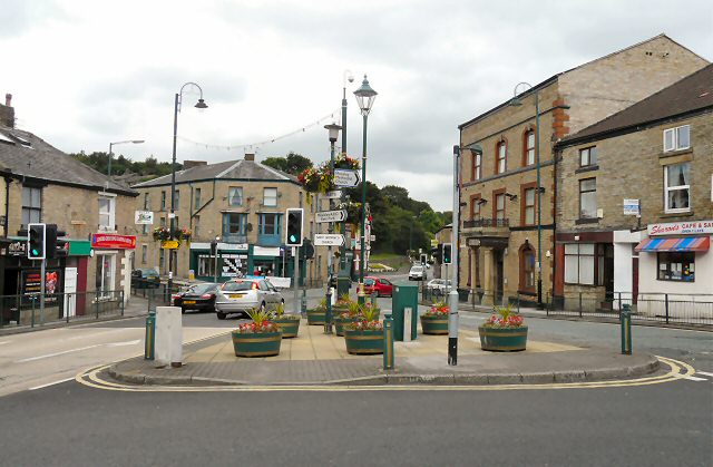
English: Top Mossley There is a confusing amount of signs and street furniture at this major junction in Top Mossley. The through route from left to right is the A670 from Ashton to Uppermill. Traffic in the opposite direction veers left (photographer's right) into Stamford Street as a one-way system operates. The road to the left at the lights leads to Lees and a right turn at the lights leads to Bottom Mossley. |
| Date | |
| Source | From geograph.org.uk |
| Author | Gerald England |
| Attribution (required by the license) | Gerald England / Top Mossley / |
| Camera location | | View this and other nearby images on: OpenStreetMap |
|---|
_heading:0.00&language=en)
| Object location | | View this and other nearby images on: OpenStreetMap |
|---|
_heading:0.00&language=en)
Licensing
edit

|
This image was taken from the Geograph project collection. See this photograph's page on the Geograph website for the photographer's contact details. The copyright on this image is owned by Gerald England and is licensed for reuse under the Creative Commons Attribution-ShareAlike 2.0 license.
|
This file is licensed under the Creative Commons Attribution-Share Alike 2.0 Generic license.
Attribution: Gerald England
- You are free:
- to share – to copy, distribute and transmit the work
- to remix – to adapt the work
- Under the following conditions:
- attribution – You must give appropriate credit, provide a link to the license, and indicate if changes were made. You may do so in any reasonable manner, but not in any way that suggests the licensor endorses you or your use.
- share alike – If you remix, transform, or build upon the material, you must distribute your contributions under the same or compatible license as the original.
File history
Click on a date/time to view the file as it appeared at that time.
| Date/Time | Thumbnail | Dimensions | User | Comment | |
|---|---|---|---|---|---|
| current | 00:12, 2 March 2011 | | 640 × 419 (114 KB) | GeographBot (talk | contribs) | == {{int:filedesc}} == {{Information |description={{en|1=Top Mossley There is a confusing amount of signs and street furniture at this major junction in Top Mossley. The through route from left to right is the A670 from Ashton to Uppermill. Traffic in the |
You cannot overwrite this file.
File usage on Commons
There are no pages that use this file.