File:Topographic map of Linhas do Porto.jpg
Original file (4,638 × 3,281 pixels, file size: 2.86 MB, MIME type: image/jpeg)
Captions
Captions
Summary
edit| Description |
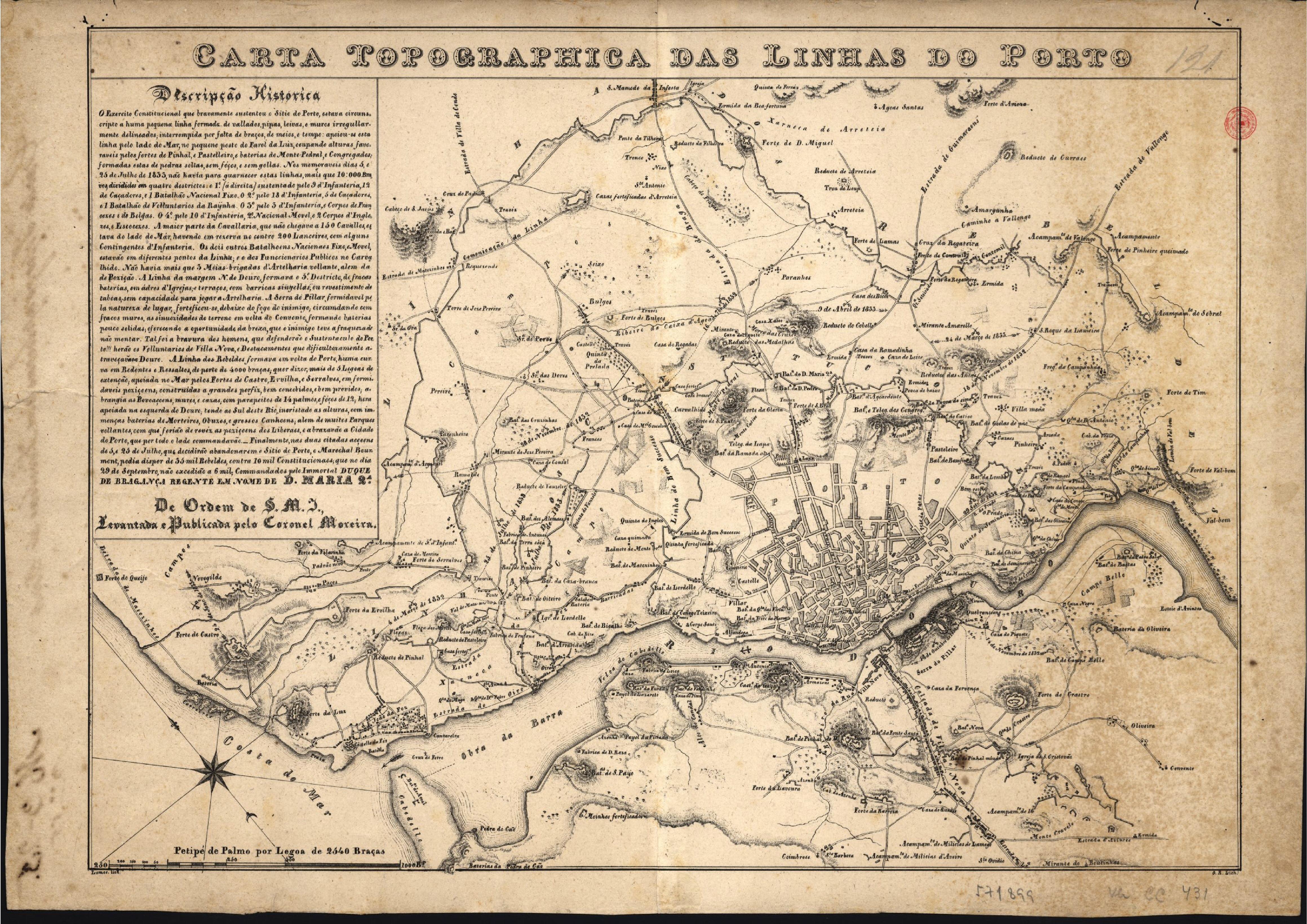
English: Topographic map of "Linhas do Porto", Siege of Porto, Liberal Wars
Português: Carta topografica das Linhas do Porto durante o Cerco do Porto Guerra Civil Portuguesa (Guerras Liberais)
ESCALA: Escala [ca 1:25400], Palmo por Legoa de 2540 Braças PUBLICAÇÃO: [S.l. : s.n. 1834] DESCR. FÍSICA: 1 mapa : litografia, p&b ; 43x31 cm NOTAS: Contém ainda escala gráfica de "1000 Braças". Mapa orientado a Nordeste. Data atribuída de acordo com o acontecimento histórico representado e com dados biográficos do autor CONTÉM: No canto superior esquerdo apresenta descrição histórica do acontecimento representado. |
||||||||||||||||||||||||||
| Date | |||||||||||||||||||||||||||
| Source | Biblioteca Nacional de Portugal: http://purl.pt/3402 | ||||||||||||||||||||||||||
| Author | Moreira, Francisco Pedro de Arbués, 1777-1843 | ||||||||||||||||||||||||||
| Institution |
|
||||||||||||||||||||||||||
| Accession number | Cota: C.C. 810 V. | ||||||||||||||||||||||||||

Licensing
edit
This image is in the public domain because it is a mere mechanical scan or photocopy of a public domain original, or – from the available evidence – is so similar to such a scan or photocopy that no copyright protection can be expected to arise. The original itself is in the public domain for the following reason:
This tag is designed for use where there may be a need to assert that any enhancements (eg brightness, contrast, colour-matching, sharpening) are in themselves insufficiently creative to generate a new copyright. It can be used where it is unknown whether any enhancements have been made, as well as when the enhancements are clear but insufficient. For known raw unenhanced scans you can use an appropriate {{PD-old}} tag instead. For usage, see Commons:When to use the PD-scan tag.  | ||||
File history
Click on a date/time to view the file as it appeared at that time.
| Date/Time | Thumbnail | Dimensions | User | Comment | |
|---|---|---|---|---|---|
| current | 06:10, 7 January 2014 | | 4,638 × 3,281 (2.86 MB) | JotaCartas (talk | contribs) | |
| 00:23, 23 July 2012 |  | 1,378 × 975 (392 KB) | JotaCartas (talk | contribs) | {{Information |Description={{en|1=Topographic map of "Linhas do Porto", Siege of Porto, Liberal Wars}} {{pt|1=Carta topografica das Linhas do Porto durante o Cerco do Porto Guerra Civil Portuguesa (Guerras Liberais) <br/>ESCALA: Escala [ca 1:25400], Pa... |
You cannot overwrite this file.
File usage on Commons
There are no pages that use this file.