File:Topographic map of Svalbard de.svg

Size of this PNG preview of this SVG file: 590 × 599 pixels. Other resolutions: 236 × 240 pixels | 472 × 480 pixels | 756 × 768 pixels | 1,008 × 1,024 pixels | 2,016 × 2,048 pixels | 2,497 × 2,537 pixels.
Original file (SVG file, nominally 2,497 × 2,537 pixels, file size: 1.4 MB)
Captions
Captions
Add a one-line explanation of what this file represents
Summary edit
| Description |
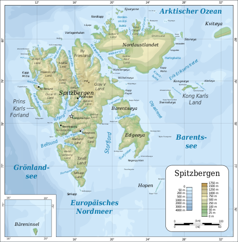
Deutsch: Topographische Karte .
English: Topographic map of Svalbard.
Suomi: Huippuvuorten topografinen kartta.
Norsk bokmål: Topografisk kart over Svalbard.
Polski: Mapa topograficzna Svalbardu.
Русский: Топографическая_карта Шпицбергена.
Українська: Топографічна_карта Свальбарда. |
||
| Date | |||
| Source |
Self-made in Inkscape by Mysid. |
||
| Author | Oona Räisänen (Mysid), German translation and minor changes by Furfur | ||
| Permission (Reusing this file) |
I, the copyright holder of this work, hereby publish it under the following licenses:
This file is licensed under the Creative Commons Attribution-Share Alike Attribution-Share Alike 4.0 International, 3.0 Unported, 2.5 Generic, 2.0 Generic and 1.0 Generic license.
You may select the license of your choice. |
||
| Other versions |
[]
|
||
| SVG development | This map was created with Adobe Illustrator. |


File history
Click on a date/time to view the file as it appeared at that time.
| Date/Time | Thumbnail | Dimensions | User | Comment | |
|---|---|---|---|---|---|
| current | 09:48, 21 September 2019 | | 2,497 × 2,537 (1.4 MB) | Furfur (talk | contribs) | Kosmetik |
| 09:36, 21 September 2019 |  | 2,497 × 2,537 (1.4 MB) | Furfur (talk | contribs) | doch eher "Spitzbergen" | |
| 09:28, 21 September 2019 |  | 2,497 × 2,537 (1.4 MB) | Furfur (talk | contribs) | == {{int:filedesc}} == {{Information |Description={{de|Topographische Karte Spitzbergens.}} {{en|Topographic map of Svalbard.}} {{fi|Huippuvuorten topografinen kartta.}} {{no|Topografisk kart over Svalbard.}} {{pl|Mapa topograficzna Svalbardu.}} {{ru|Топографическая_карта Шпицбергена.}} {{uk|Топографічна_карта Свальбарда.}} |Source=Self-made in Inkscape b... |
You cannot overwrite this file.
File usage on Commons
The following 4 pages use this file:
File usage on other wikis
The following other wikis use this file:
- Usage on de.wikipedia.org