File:Topographical map, 1st Brigade, defenses north of Potomac, Washington, D.C. (EAST).jpg
Size of this preview: 800 × 392 pixels. Other resolutions: 320 × 157 pixels | 640 × 314 pixels | 1,024 × 502 pixels | 1,280 × 627 pixels | 2,560 × 1,254 pixels | 5,918 × 2,899 pixels.
Original file (5,918 × 2,899 pixels, file size: 1.85 MB, MIME type: image/jpeg)
Captions
Captions
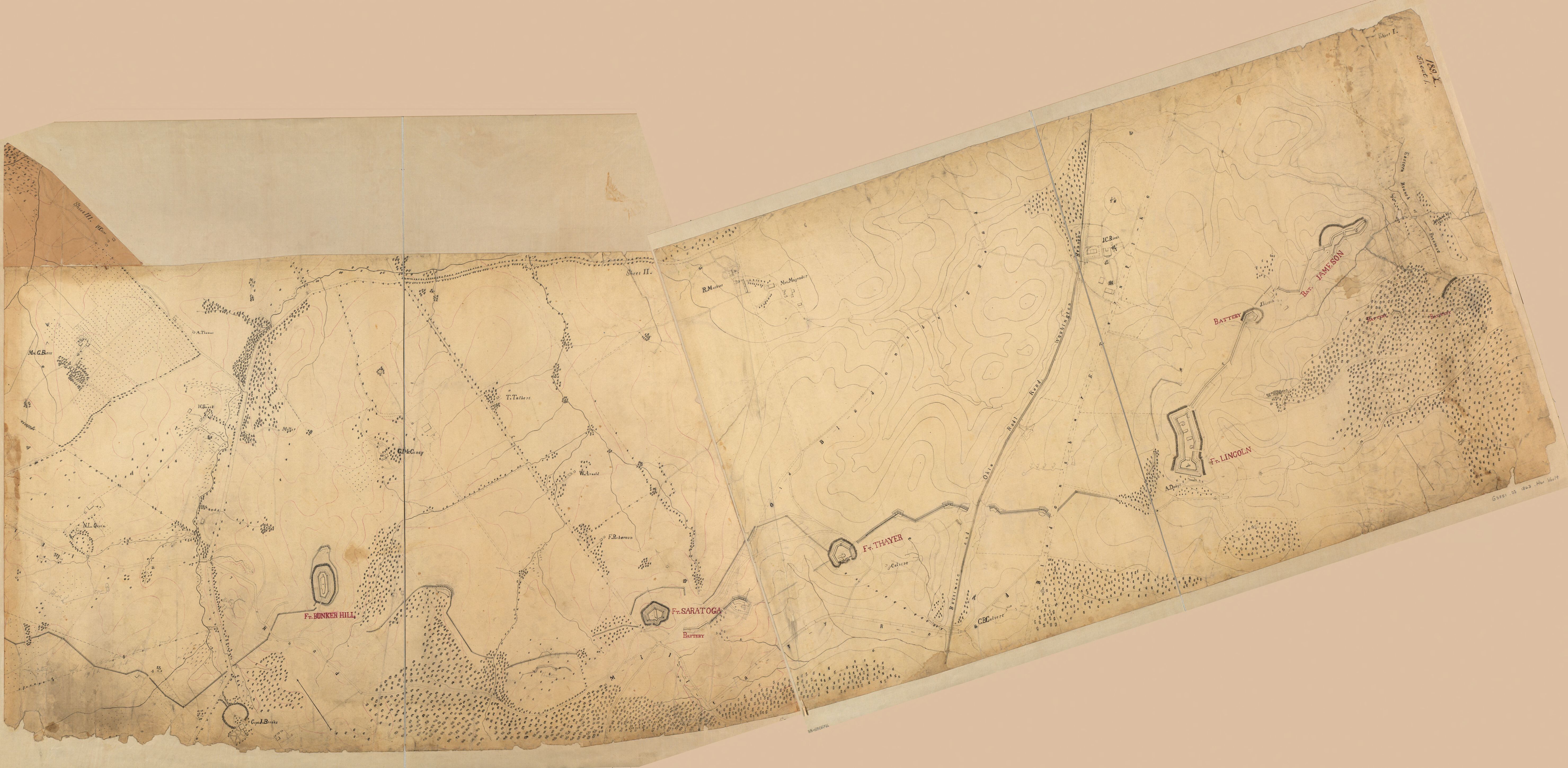
American Civil War Union Army defenses of Washington, D.C.
Summary
edit| Description |
English: Map covers environs of Forts De Russy, Stevens, Slocum, Totten, Slemmer, Bunker Hill, Saratoga, Thayer, Lincoln, and Batteries Sill and Jameson. Includes some buildings, lot lines, householders' names, forts, and vegetation. Material used: India and red inks. |
||
| Date | |||
| Source |
|
||
| Author | R. A. Hodasevich | ||
| Other versions |
 |

.jpg)
.jpg)
.jpg)
.jpg)
.jpg)
.jpg&action=edit§ion=1)
Licensing
edit.jpg&action=edit§ion=2)
|
This work is in the public domain in its country of origin and other countries and areas where the copyright term is the author's life plus 70 years or fewer. This work is in the public domain in the United States because it was published (or registered with the U.S. Copyright Office) before January 1, 1929. | |
| This file has been identified as being free of known restrictions under copyright law, including all related and neighboring rights. | |
File history
Click on a date/time to view the file as it appeared at that time.
| Date/Time | Thumbnail | Dimensions | User | Comment | |
|---|---|---|---|---|---|
| current | 11:10, 15 November 2019 | | 5,918 × 2,899 (1.85 MB) | Dcflyer (talk | contribs) | User created page with UploadWizard |
You cannot overwrite this file.
File usage on Commons
The following 6 pages use this file:
- File:Fort Bunker Hill — Topographical map, 1st Brigade, defenses north of Potomac, Washington, D.C. (EAST).jpg
- File:Fort Lincoln and Battery Jameson — Topographical map, 1st Brigade, defenses north of Potomac, Washington, D.C. (EAST).jpg
- File:Fort Lincoln — Topographical map, 1st Brigade, defenses north of Potomac, Washington, D.C. (EAST).jpg
- File:Fort Saratoga — Topographical map, 1st Brigade, defenses north of Potomac, Washington, D.C. (EAST).jpg
- File:Fort Thayer — Topographical map, 1st Brigade, defenses north of Potomac, Washington, D.C. (EAST).jpg
- File:Topographical map, 1st Brigade, defenses north of Potomac, Washington, D.C. LOC 88690656.jpg
.jpg&oldid=635388007)