File:Topographical map of the Antipodes Islands in English.svg

Size of this PNG preview of this SVG file: 760 × 600 pixels. Other resolutions: 304 × 240 pixels | 608 × 480 pixels | 973 × 768 pixels | 1,280 × 1,010 pixels | 2,560 × 2,020 pixels | 1,242 × 980 pixels.
Original file (SVG file, nominally 1,242 × 980 pixels, file size: 164 KB)
Captions
Captions
Add a one-line explanation of what this file represents
Summary edit
| Description |
English:
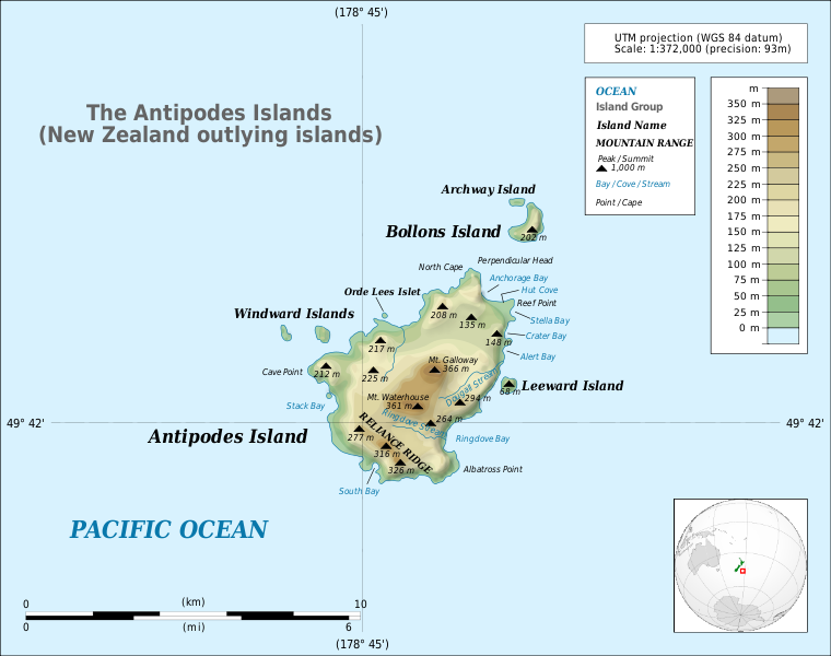
Detailed map of large dimensions. For superior viewing, click on the link of the image above. Topographic map in English of the Antipodes Islands near New Zealand.
|
|||
| Date | (UTC) | |||
| Source |
Own work
This vector image includes elements that have been taken or adapted from this file: |
|||
| Author | Matthewedwards | |||
| Permission (Reusing this file) |
I, the copyright holder of this work, hereby publish it under the following license:
|
|||
| Other versions |
|
|||
| SVG development |


_2.svg)
File history
Click on a date/time to view the file as it appeared at that time.
| Date/Time | Thumbnail | Dimensions | User | Comment | |
|---|---|---|---|---|---|
| current | 12:20, 26 October 2010 | | 1,242 × 980 (164 KB) | Avenue (talk | contribs) | Fix typo in title. |
| 19:13, 21 July 2010 |  | 1,242 × 980 (164 KB) | Matthewedwards (talk | contribs) | {{Information |Description={{en|1=<div style="background:#ffffd9; border:1px solid #aaaaaa;" align="left" cellpadding="7" cellspacing="1" width="100%"> <div style="float:left; margin: 0.4em;"> 28px| </div> <small> ''De |
You cannot overwrite this file.
File usage on Commons
The following 2 pages use this file:
File usage on other wikis
The following other wikis use this file:
- Usage on ar.wikipedia.org
- Usage on az.wikipedia.org
- Usage on bg.wikipedia.org
- Usage on ca.wikipedia.org
- Usage on cs.wikipedia.org
- Usage on de.wikipedia.org
- Usage on en.wikipedia.org
- Usage on eo.wikipedia.org
- Usage on fr.wikipedia.org
- Usage on gl.wikipedia.org
- Usage on hr.wikipedia.org
- Usage on hy.wikipedia.org
- Usage on it.wikipedia.org
- Usage on ja.wikipedia.org
- Usage on ka.wikipedia.org
- Usage on lt.wikipedia.org
- Usage on ml.wikipedia.org
- Usage on mrj.wikipedia.org
- Usage on nl.wikipedia.org
- Usage on no.wikipedia.org
- Usage on pl.wikipedia.org
- Usage on pt.wikipedia.org
- Usage on ru.wikipedia.org
- Usage on sh.wikipedia.org
- Usage on sr.wikipedia.org
- Usage on sv.wikipedia.org
- Usage on vi.wikipedia.org
- Usage on www.wikidata.org