File:Topographie de biarritz anglet bayonne.jpg

Size of this preview: 600 × 600 pixels. Other resolutions: 240 × 240 pixels | 480 × 480 pixels | 768 × 768 pixels | 1,024 × 1,024 pixels | 1,280 × 1,280 pixels.
Original file (1,280 × 1,280 pixels, file size: 647 KB, MIME type: image/jpeg)
Captions
Captions
Add a one-line explanation of what this file represents
Originally uploaded to french Wikipedia by Uitilisateur:NaSH (00:33 17 november 2004), who made these comments:
--
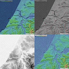
Topographie de Biarritz, Anglet, Bayonne
4 images topographique (20 km de coté) de Biarritz, Anglet, Bayonne prisent par la mission SRTM.
- Image topographique + position des villes
- image topographique en relief + position des villes
- image topographique en niveau de gris (utile pour displacement map dans les logiciel 3D)
- Image topographique sans les villes
Générée par le logiciel Radiomobile à partir des données domaine public de la mission SRTM de la NASA.
This image uses high-resolution digital topography data from NASA's Shuttle Radar Topography Mission (SRTM) at JPL-Caltech [1]. It is in the public domain in the United States.
|
 | |
File history
Click on a date/time to view the file as it appeared at that time.
| Date/Time | Thumbnail | Dimensions | User | Comment | |
|---|---|---|---|---|---|
| current | 09:21, 27 October 2005 | | 1,280 × 1,280 (647 KB) | Ylebru (talk | contribs) | uploaded in fr:wiki by Uitilisateur:NaSH, with these comments: -- Topographie de Biarritz, Anglet, Bayonne 4 images topographique (20 km de coté) de Biarritz, Anglet, Bayonne prisent par la mission SRTM. * Image topographique + position des villes * |
You cannot overwrite this file.
File usage on Commons
There are no pages that use this file.