File:Torun Brama Starotorunska od wschodu.jpg

Original file (789 × 886 pixels, file size: 105 KB, MIME type: image/jpeg)
Captions
Captions
Summary
edit
| Description |
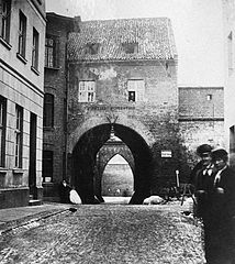
English: Starotoruńska Gate in Toruń ruined in 1887 seen from the inner, eastside
Polski: Brama Starotoruńska w Toruniu zburzona ok. roku 1887 widziana od strony wschodniej |
| Date | |
| Source | skyscrapercity forum |
| Author | Unknown author |
| Camera location | | View this and other nearby images on: OpenStreetMap |
|---|
Licensing
edit
|
This work is in the public domain in its country of origin and other countries and areas where the copyright term is the author's life plus 70 years or fewer.
| |
| This file has been identified as being free of known restrictions under copyright law, including all related and neighboring rights. | |
File history
Click on a date/time to view the file as it appeared at that time.
| Date/Time | Thumbnail | Dimensions | User | Comment | |
|---|---|---|---|---|---|
| current | 12:52, 27 May 2009 | | 789 × 886 (105 KB) | J a1 (talk | contribs) | {{Information |Description={{en|1=Starotoruńska Gate in Toruń ruined in 1887 seen from the inner, eastside}} {{pl|1=Brama Starotoruńska w Toruniu zburzona ok. roku 1887 widziana od strony wschodniej }} |Source=[http://www.skyscrapercity.com/showthread. |
You cannot overwrite this file.
File usage on Commons
The following page uses this file:
File usage on other wikis
The following other wikis use this file:
- Usage on pl.wikipedia.org