File:Toulouse Reseau Lignes ABCE.svg

Size of this PNG preview of this SVG file: 586 × 548 pixels. Other resolutions: 257 × 240 pixels | 513 × 480 pixels | 821 × 768 pixels | 1,095 × 1,024 pixels | 2,190 × 2,048 pixels.
Original file (SVG file, nominally 586 × 548 pixels, file size: 96 KB)
Captions
Captions
Add a one-line explanation of what this file represents
Summary
edit
| Description |
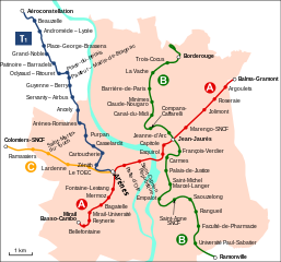
Français : Carte géographiquement exacte des lignes A, B, C et E du système de transport public toulousain |
| Date | |
| Source | travail personnel (own work) from File:Toulouse Reseau Metro.svg |
| Author | Sardon |
Licensing
edit

|
Permission is granted to copy, distribute and/or modify this document under the terms of the GNU Free Documentation License, Version 1.2 or any later version published by the Free Software Foundation; with no Invariant Sections, no Front-Cover Texts, and no Back-Cover Texts. A copy of the license is included in the section entitled GNU Free Documentation License. |
| This file is licensed under the Creative Commons Attribution-Share Alike 3.0 Unported license. | ||
| ||
| This licensing tag was added to this file as part of the GFDL licensing update. |
File history
Click on a date/time to view the file as it appeared at that time.
| Date/Time | Thumbnail | Dimensions | User | Comment | |
|---|---|---|---|---|---|
| current | 13:02, 18 November 2010 | | 586 × 548 (96 KB) | Ricou31 (talk | contribs) | Tisseo a finalement décidé de nommer la ligne de tramway ''T1'' et non ''Ligne C'', le terminus est rebaptisé ''Aérocontellation'' |
| 20:18, 14 January 2009 |  | 586 × 548 (92 KB) | Sardon (talk | contribs) | {{Information |Description={{fr|1=Carte géographiquement exacte des lignes A, B, C et E du système de transport public toulousain}} |Source=travail personnel (own work) from File:Toulouse Reseau Metro.svg |Author=Sardon |Date=2009-0 |
You cannot overwrite this file.
File usage on Commons
There are no pages that use this file.
File usage on other wikis
The following other wikis use this file:
- Usage on de.wikivoyage.org
- Usage on eo.wikipedia.org
- Usage on fi.wikipedia.org
- Usage on fr.wikipedia.org
- Usage on ja.wikipedia.org
- Usage on ja.wikivoyage.org
- Usage on pl.wikipedia.org
- Usage on uk.wikipedia.org