File:Tour-du-maregraphe-de-la-Ra.jpg

Size of this preview: 730 × 600 pixels. Other resolutions: 292 × 240 pixels | 584 × 480 pixels | 935 × 768 pixels | 1,246 × 1,024 pixels | 2,442 × 2,007 pixels.
Original file (2,442 × 2,007 pixels, file size: 710 KB, MIME type: image/jpeg)
Captions
Captions
Add a one-line explanation of what this file represents
Summary
edit
| Description |
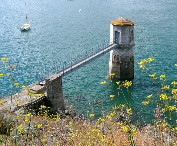
English: Tide gauge station in the Rance River (Saint Malo, France). Build in 1844. Now used by the Rance tidal power plant
Français : Tour du marégraphe de la Rance située à Saint Servan (commune de Saint Malo, Bretagne, France. Un marégraphe est un instrument qui permet de mesurer le niveau de la mer.
La passerelle donne accès à la salle d'enregistrement située au dessus de l'instrument de mesure. Construit en 1844, il est entièrement automatisé et donne la hauteur d'eau de la baie de Saint-Malo. |
| Date | |
| Source | Own work |
| Author | Pline |
Licensing
edit
I, the copyright holder of this work, hereby publish it under the following licenses:

|
Permission is granted to copy, distribute and/or modify this document under the terms of the GNU Free Documentation License, Version 1.2 or any later version published by the Free Software Foundation; with no Invariant Sections, no Front-Cover Texts, and no Back-Cover Texts. A copy of the license is included in the section entitled GNU Free Documentation License. |
This file is licensed under the Creative Commons Attribution-Share Alike 3.0 Unported, 2.5 Generic, 2.0 Generic and 1.0 Generic license.
- You are free:
- to share – to copy, distribute and transmit the work
- to remix – to adapt the work
- Under the following conditions:
- attribution – You must give appropriate credit, provide a link to the license, and indicate if changes were made. You may do so in any reasonable manner, but not in any way that suggests the licensor endorses you or your use.
- share alike – If you remix, transform, or build upon the material, you must distribute your contributions under the same or compatible license as the original.
You may select the license of your choice.
File history
Click on a date/time to view the file as it appeared at that time.
| Date/Time | Thumbnail | Dimensions | User | Comment | |
|---|---|---|---|---|---|
| current | 12:12, 4 September 2008 | | 2,442 × 2,007 (710 KB) | Pline (talk | contribs) | {{Information |Description={{en|1=Tide gauge station in the Rance River (Saint Malo, France). Build in 1844. Now used by the Rance tidal power plant }} {{fr|1=Tour du marégraphe de la Rance située à Saint Servan (commune de Saint Malo, Bretagne, France |
You cannot overwrite this file.
File usage on Commons
The following 2 pages use this file:
File usage on other wikis
The following other wikis use this file:
- Usage on bg.wikipedia.org
- Usage on fr.wikipedia.org
- Usage on nl.wikipedia.org
- Usage on pt.wikipedia.org
- Usage on vi.wikipedia.org