File:Tower block collapse. Canning Town (geograph 2540469).jpg

Size of this preview: 424 × 599 pixels. Other resolutions: 170 × 240 pixels | 566 × 800 pixels.
Original file (566 × 800 pixels, file size: 85 KB, MIME type: image/jpeg)
Captions
Captions
Add a one-line explanation of what this file represents
Summary
edit.jpg&action=edit§ion=1)
| Description |
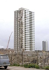
English: Tower block collapse. Canning Town. This was Ronan Point, a 21 storey high block of flats in East London. Completed on the 11th March 1968. Just two months later on the 16th May, a gas explosion on the 18th floor blew out the walls supporting the floors above, which brought about the progressive collapse of this corner of the block, killing four people. Luckily it occurred at a time when most of the residents were still in bed away from the destroyed sitting rooms. The block was re-built quickly but subsequently demolished in 1986 |
| Date | |
| Source | From geograph.org.uk |
| Author | Derek Voller |
| Permission (Reusing this file) |
Creative Commons Attribution Share-alike license 2.0 |
| Attribution (required by the license) | Derek Voller / Tower block collapse. Canning Town / |
| Camera location | | View this and other nearby images on: OpenStreetMap |
|---|
.jpg¶ms=051.514613_N_0000.012172_E_globe:Earth_type:camera_heading:112.00_source:geograph&language=en)
| Object location | | View this and other nearby images on: OpenStreetMap |
|---|
.jpg¶ms=051.514280_N_0000.013200_E_globe:Earth_class:object_type:object_source:geograph-osgb36(TQ39798140)_region:GB-GBN_heading:112.00&language=en)
Licensing
edit.jpg&action=edit§ion=2)

|
This image was taken from the Geograph project collection. See this photograph's page on the Geograph website for the photographer's contact details. The copyright on this image is owned by Derek Voller and is licensed for reuse under the Creative Commons Attribution-ShareAlike 2.0 license.
|
This file is licensed under the Creative Commons Attribution-Share Alike 2.0 Generic license.
Attribution: Derek Voller
- You are free:
- to share – to copy, distribute and transmit the work
- to remix – to adapt the work
- Under the following conditions:
- attribution – You must give appropriate credit, provide a link to the license, and indicate if changes were made. You may do so in any reasonable manner, but not in any way that suggests the licensor endorses you or your use.
- share alike – If you remix, transform, or build upon the material, you must distribute your contributions under the same or compatible license as the original.
File history
Click on a date/time to view the file as it appeared at that time.
| Date/Time | Thumbnail | Dimensions | User | Comment | |
|---|---|---|---|---|---|
| current | 16:40, 14 June 2017 | | 566 × 800 (85 KB) | Gapfall (talk | contribs) | Transferred from geograph.co.uk using [https://tools.wmflabs.org/geograph2commons/ geograph2commons] |
You cannot overwrite this file.
File usage on Commons
The following page uses this file:
File usage on other wikis
The following other wikis use this file:
- Usage on es.wikipedia.org
- Usage on uk.wikipedia.org
- Usage on www.wikidata.org
.jpg&oldid=726555333)