File:Tower of St Peter and St Pauls Chursh, Wisbech.JPG
Original file (3,000 × 5,333 pixels, file size: 1.22 MB, MIME type: image/jpeg)
Captions
Captions
This image is very small, unfixably too light/dark, or may not adequately illustrate the subject of the image If a higher-quality version of this particular image is available, please replace this one; otherwise, a supplemental image illustrating this subject and available under a free license should be found or provided and uploaded as a separate file.
Please see Category:Image cleanup templates for templates used to mark images that only need a clean-up. For more help, see Commons:Media for cleanup#Low quality images. العربية ∙ беларуская (тарашкевіца) ∙ català ∙ čeština ∙ Deutsch ∙ English ∙ español ∙ فارسی ∙ suomi ∙ français ∙ galego ∙ magyar ∙ italiano ∙ 日本語 ∙ ಕನ್ನಡ ∙ 한국어 ∙ македонски ∙ മലയാളം ∙ Plattdüütsch ∙ Nederlands ∙ norsk ∙ polski ∙ português ∙ русский ∙ sicilianu ∙ slovenščina ∙ svenska ∙ Tiếng Việt ∙ 中文 ∙ 中文(简体) ∙ 中文(繁體) ∙ 中文(臺灣) ∙ +/− |
==Summary==
DescriptionTower of St Peter and St Pauls Chursh, Wisbech.JPG |
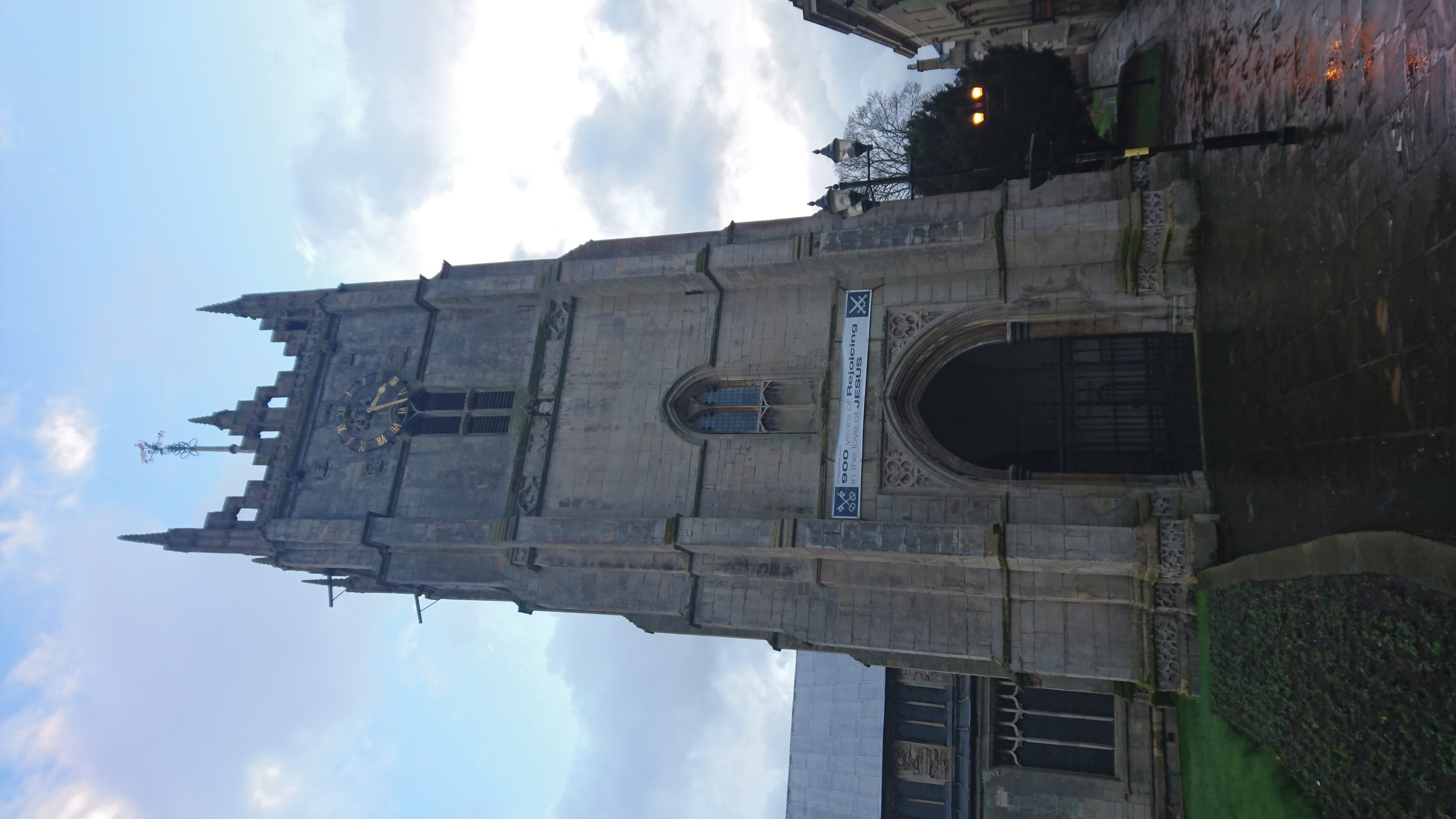
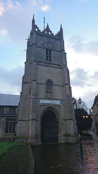
English: Tower of SS Peter and Paul parish church, Wisbech, Cambridgeshire, seen from Church Terrace |
Date | |
Source | Own work |
Author | Gyrwan |
Camera location | 52° 39′ 51.48″ N, 0° 09′ 42.12″ E ![]() | View this and other nearby images on: OpenStreetMap | ![]() |
---|
Licensing
edit![w:en:Creative Commons](https://upload.wikimedia.org/wikipedia/commons/thumb/7/79/CC_some_rights_reserved.svg/90px-CC_some_rights_reserved.svg.png)
![attribution](https://upload.wikimedia.org/wikipedia/commons/thumb/1/11/Cc-by_new_white.svg/24px-Cc-by_new_white.svg.png)
- You are free:
- to share – to copy, distribute and transmit the work
- to remix – to adapt the work
- Under the following conditions:
- attribution – You must give appropriate credit, provide a link to the license, and indicate if changes were made. You may do so in any reasonable manner, but not in any way that suggests the licensor endorses you or your use.
File history
Click on a date/time to view the file as it appeared at that time.
Date/Time | Thumbnail | Dimensions | User | Comment | |
---|---|---|---|---|---|
current | 01:02, 15 January 2016 | 3,000 × 5,333 (1.22 MB) | Gyrwan (talk | contribs) | User created page with UploadWizard |
You cannot overwrite this file.
File usage on Commons
There are no pages that use this file.
Metadata
This file contains additional information such as Exif metadata which may have been added by the digital camera, scanner, or software program used to create or digitize it. If the file has been modified from its original state, some details such as the timestamp may not fully reflect those of the original file. The timestamp is only as accurate as the clock in the camera, and it may be completely wrong.
Camera manufacturer | SONY |
---|---|
Camera model | E5823 |
Exposure time | 1/100 sec (0.01) |
F-number | f/2 |
ISO speed rating | 50 |
Date and time of data generation | 15:33, 12 January 2016 |
Lens focal length | 4.23 mm |
Latitude | 52° 39′ 51.52″ N |
Longitude | 0° 9′ 42.56″ E |
Altitude | 74 meters above sea level |
Orientation | Rotated 90° CCW |
Horizontal resolution | 72 dpi |
Vertical resolution | 72 dpi |
Software used | 32.0.A.6.200_0_f500 |
File change date and time | 15:33, 12 January 2016 |
Y and C positioning | Centered |
Exif version | 2.2 |
Date and time of digitizing | 15:33, 12 January 2016 |
Meaning of each component |
|
APEX shutter speed | 6.64 |
APEX exposure bias | 0 |
Metering mode | Pattern |
Light source | Unknown |
Flash | Flash did not fire, auto mode |
DateTime subseconds | 772130 |
DateTimeOriginal subseconds | 772130 |
DateTimeDigitized subseconds | 772130 |
Supported Flashpix version | 1 |
Color space | sRGB |
Custom image processing | Normal process |
Exposure mode | Auto exposure |
White balance | Auto white balance |
Digital zoom ratio | 1 |
Scene capture type | Standard |
Subject distance range | Unknown |
Unique image ID | 454c033a71995df50000000000000000 |
GPS time (atomic clock) | 15:33 |
Receiver status | Measurement in progress |
Geodetic survey data used | WGS-84 |
GPS date | 12 January 2016 |
GPS tag version | 0.0.2.2 |