File:Tracks of Central Pacific Hurricanes 1949 to 1998.gif
No higher resolution available.
Tracks_of_Central_Pacific_Hurricanes_1949_to_1998.gif (542 × 356 pixels, file size: 26 KB, MIME type: image/gif)
Captions
Captions
Add a one-line explanation of what this file represents
Summary edit
| Description |
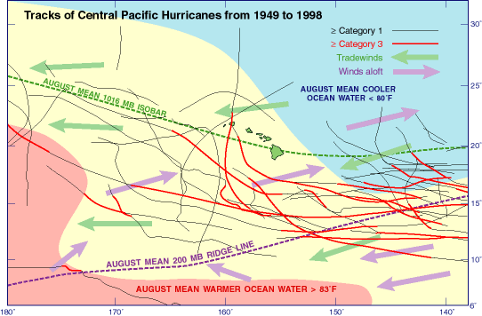
English: Hurricanes in the Central Pacific (140° W to 180 ° W) generally travel from east to west, however, some including
Hurricanes Iwa (1982) and Iniki (1992) track in a northerly direction. (mb, pressure in millibars). |
| Date | |
| Source | http://pubs.usgs.gov/imap/i2761/sections/1_Intro.pdf -- Page 15 |
| Author | USGS |
This is a creation of a US Federal Government employee
Licensing edit
This image is in the public domain in the United States because it only contains materials that originally came from the United States Geological Survey, an agency of the United States Department of the Interior. For more information, see the official USGS copyright policy.
|
File history
Click on a date/time to view the file as it appeared at that time.
| Date/Time | Thumbnail | Dimensions | User | Comment | |
|---|---|---|---|---|---|
| current | 03:19, 10 June 2011 | | 542 × 356 (26 KB) | Pbmaise (talk | contribs) | {{Information |Description ={{en|1=Hurricanes in the Central Pacific (140° W to 180 ° W) generally travel from east to west, however, some including Hurricanes Iwa (1982) and Iniki (1992) track in a northerly direction. (mb, pressure in millibars).}} |
You cannot overwrite this file.
File usage on Commons
There are no pages that use this file.
File usage on other wikis
The following other wikis use this file:
- Usage on en.wikipedia.org