File:Trails of Cascade Range map-it.svg

Size of this PNG preview of this SVG file: 348 × 598 pixels. Other resolutions: 139 × 240 pixels | 279 × 480 pixels | 446 × 768 pixels | 595 × 1,024 pixels | 1,191 × 2,048 pixels | 403 × 693 pixels.
Original file (SVG file, nominally 403 × 693 pixels, file size: 2.65 MB)
Captions
Captions
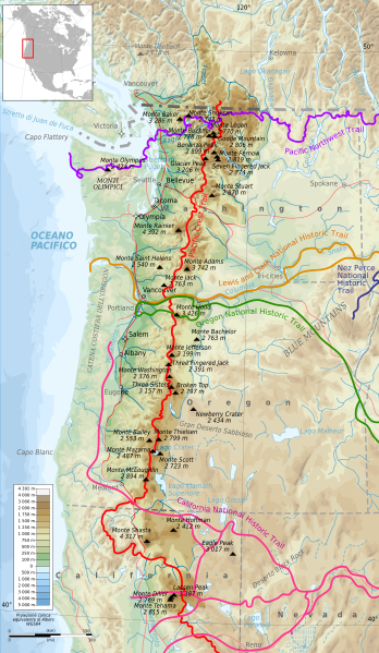
Map of Cascade Range showing some trails.
Summary
edit
| Description |
English: Map of Cascade Range showing some trails.
Français : Carte topographique de la Chaîne des Cascades montrant divers chemins de grande randonnée.
Italiano: Mappa topografica della Catena delle Cascate che mostra vari sentieri escursionistici. |
| Date | |
| Source | File:Trails of Cascade Range map-fr.svg |
| Author | Bourrichon (original file) - User:Nancystodd (translation to Italian) |
Licensing
edit
This file is licensed under the Creative Commons Attribution-Share Alike 4.0 International license.
- You are free:
- to share – to copy, distribute and transmit the work
- to remix – to adapt the work
- Under the following conditions:
- attribution – You must give appropriate credit, provide a link to the license, and indicate if changes were made. You may do so in any reasonable manner, but not in any way that suggests the licensor endorses you or your use.
- share alike – If you remix, transform, or build upon the material, you must distribute your contributions under the same or compatible license as the original.
File history
Click on a date/time to view the file as it appeared at that time.
| Date/Time | Thumbnail | Dimensions | User | Comment | |
|---|---|---|---|---|---|
| current | 17:13, 29 August 2021 | | 403 × 693 (2.65 MB) | Nancystodd (talk | contribs) | Corrected another error |
| 17:08, 29 August 2021 |  | 403 × 693 (2.65 MB) | Nancystodd (talk | contribs) | Corrected translation errors | |
| 22:37, 27 August 2021 |  | 403 × 693 (2.65 MB) | Nancystodd (talk | contribs) | Uploaded a work by Bourrichon (original file) - User:Nancystodd (translation to Italian) from File:Trails of Cascade Range map-fr.svg with UploadWizard |
You cannot overwrite this file.
File usage on Commons
The following page uses this file:
File usage on other wikis
The following other wikis use this file:
- Usage on it.wikipedia.org