File:Tramway map of Antwerpen.png

Size of this preview: 800 × 552 pixels. Other resolutions: 320 × 221 pixels | 640 × 442 pixels | 1,024 × 707 pixels | 1,280 × 884 pixels | 2,560 × 1,767 pixels | 4,511 × 3,114 pixels.
Original file (4,511 × 3,114 pixels, file size: 4.23 MB, MIME type: image/png)
Captions
Captions
Add a one-line explanation of what this file represents
| Description |
|
|||
| Date | ||||
| Source | Own work, using OpenStreetMap data for the background | |||
| Author | Maximilian Dörrbecker (Chumwa) | |||
| Permission (Reusing this file) |
All OpenStreetMap data and maps are Creative Commons "CC-BY-SA 2.0" licensed This file is licensed under the Creative Commons Attribution-Share Alike 2.0 Generic license.
|
|||
| Other versions |
|

.png)
File history
Click on a date/time to view the file as it appeared at that time.
| Date/Time | Thumbnail | Dimensions | User | Comment | |
|---|---|---|---|---|---|
| current | 06:57, 11 May 2015 | | 4,511 × 3,114 (4.23 MB) | Chumwa (talk | contribs) | corr |
| 22:11, 1 May 2015 |  | 4,511 × 3,114 (3.75 MB) | Wester (talk | contribs) | Borsbek > Borsbeek | |
| 18:54, 30 April 2015 |  | 4,511 × 3,114 (4.23 MB) | Chumwa (talk | contribs) | Premetro-Stationen gesondert gekennzeichnet | |
| 05:01, 30 April 2015 |  | 4,511 × 3,114 (4.23 MB) | Chumwa (talk | contribs) | Bauvorleistungen für Premetro hinzugefügt | |
| 05:25, 29 April 2015 |  | 4,511 × 3,114 (4.15 MB) | Chumwa (talk | contribs) | Umlandgemeinden hinzugefügt | |
| 20:14, 28 April 2015 |  | 4,511 × 3,114 (4.07 MB) | Chumwa (talk | contribs) | Stadtgrenze und Distriktgrenzen hinzugefügt | |
| 05:39, 28 April 2015 |  | 4,511 × 3,114 (4.19 MB) | Chumwa (talk | contribs) | corr | |
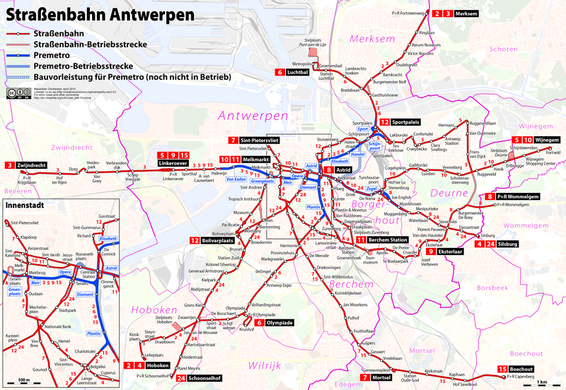
| 04:57, 28 April 2015 |  | 4,511 × 3,114 (4.18 MB) | Chumwa (talk | contribs) | {{Information |Description= *{{de|Karte: Netzplan der Straßenbahn Antwerpen}} *{{en|Map of the Antwerp tramway}} *{{fr|Plan du réseau de tramway d'Anvers}} {{Overlay}} |Author=Maximilian Dörrbecker (Chumwa) |... |
You cannot overwrite this file.
File usage on Commons
The following 10 pages use this file:
- User:Chumwa/Gallery
- User:Chumwa/OgreBot/Public transport information/2015 April 21-30
- User:Chumwa/OgreBot/Public transport information/2015 May 1-10
- User:Chumwa/OgreBot/Public transport information/2015 May 11-20
- User:Chumwa/OgreBot/Transport Maps/2015 April 21-30
- User:Chumwa/OgreBot/Transport Maps/2015 May 1-10
- User:Chumwa/OgreBot/Transport Maps/2015 May 11-20
- File:Tramway map of Antwerpen.png
- File:Tramway map of Antwerpen (without background).png
- Category:Trams in Antwerp
File usage on other wikis
The following other wikis use this file:
- Usage on de.wikipedia.org
- Usage on eo.wikipedia.org
- Usage on eu.wikipedia.org
- Usage on fr.wikipedia.org
- Usage on hu.wikipedia.org
- Usage on it.wikipedia.org
- Usage on ja.wikipedia.org
- Usage on lv.wikipedia.org
- Usage on nl.wikipedia.org
- Usage on pt.wikipedia.org
- Usage on ro.wikipedia.org
- Usage on ru.wikipedia.org
- Usage on sv.wikipedia.org
- Usage on uk.wikipedia.org
- Usage on www.wikidata.org