File:Tranquility perhaps - geograph.org.uk - 749813.jpg
No higher resolution available.
Tranquility_perhaps_-_geograph.org.uk_-_749813.jpg (640 × 480 pixels, file size: 162 KB, MIME type: image/jpeg)
Captions
Captions
Add a one-line explanation of what this file represents
Summary edit
| Description |
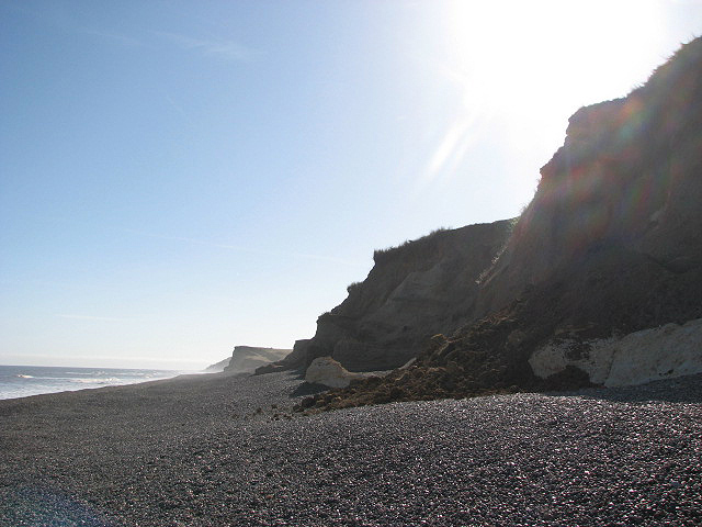
English: Tranquility perhaps But closer observation reveals evident signs of erosion such as seen here at right, where a section of cliff has recently tumbled onto the shingle beach. Up to 2.5 metres (in some areas 5 metres) of headland is falling into the sea every year along this section of the coast.
Many people enjoy the clifftop views offered by the Norfolk Coast Path/Peddars Way, up on the headland, skirting the cliffs seen here. The cliffs are steep, unstable and dangerous, there is no access path leading onto the beach, and walking on the shingle is difficult. |
| Date | |
| Source | From geograph.org.uk |
| Author | Evelyn Simak |
| Attribution (required by the license) | Evelyn Simak / Tranquility perhaps / |
| Camera location | | View this and other nearby images on: OpenStreetMap |
|---|
_heading:90.00&language=en)
| Object location | | View this and other nearby images on: OpenStreetMap |
|---|
_heading:90.00&language=en)
Licensing edit

|
This image was taken from the Geograph project collection. See this photograph's page on the Geograph website for the photographer's contact details. The copyright on this image is owned by Evelyn Simak and is licensed for reuse under the Creative Commons Attribution-ShareAlike 2.0 license.
|
This file is licensed under the Creative Commons Attribution-Share Alike 2.0 Generic license.
Attribution: Evelyn Simak
- You are free:
- to share – to copy, distribute and transmit the work
- to remix – to adapt the work
- Under the following conditions:
- attribution – You must give appropriate credit, provide a link to the license, and indicate if changes were made. You may do so in any reasonable manner, but not in any way that suggests the licensor endorses you or your use.
- share alike – If you remix, transform, or build upon the material, you must distribute your contributions under the same or compatible license as the original.
File history
Click on a date/time to view the file as it appeared at that time.
| Date/Time | Thumbnail | Dimensions | User | Comment | |
|---|---|---|---|---|---|
| current | 13:03, 19 February 2011 | | 640 × 480 (162 KB) | GeographBot (talk | contribs) | == {{int:filedesc}} == {{Information |description={{en|1=Tranquility perhaps But closer observation reveals evident signs of erosion such as seen here at right, where a section of cliff has recently tumbled onto the shingle beach. Up to 2.5 metres (in som |
You cannot overwrite this file.
File usage on Commons
There are no pages that use this file.