File:Transilien, carte détaillée Paris et environs.svg

Size of this PNG preview of this SVG file: 661 × 599 pixels. Other resolutions: 265 × 240 pixels | 529 × 480 pixels | 847 × 768 pixels | 1,129 × 1,024 pixels | 2,259 × 2,048 pixels | 1,469 × 1,332 pixels.
Original file (SVG file, nominally 1,469 × 1,332 pixels, file size: 2.45 MB)
Captions
Captions
Add a one-line explanation of what this file represents
Summary edit
| Description |
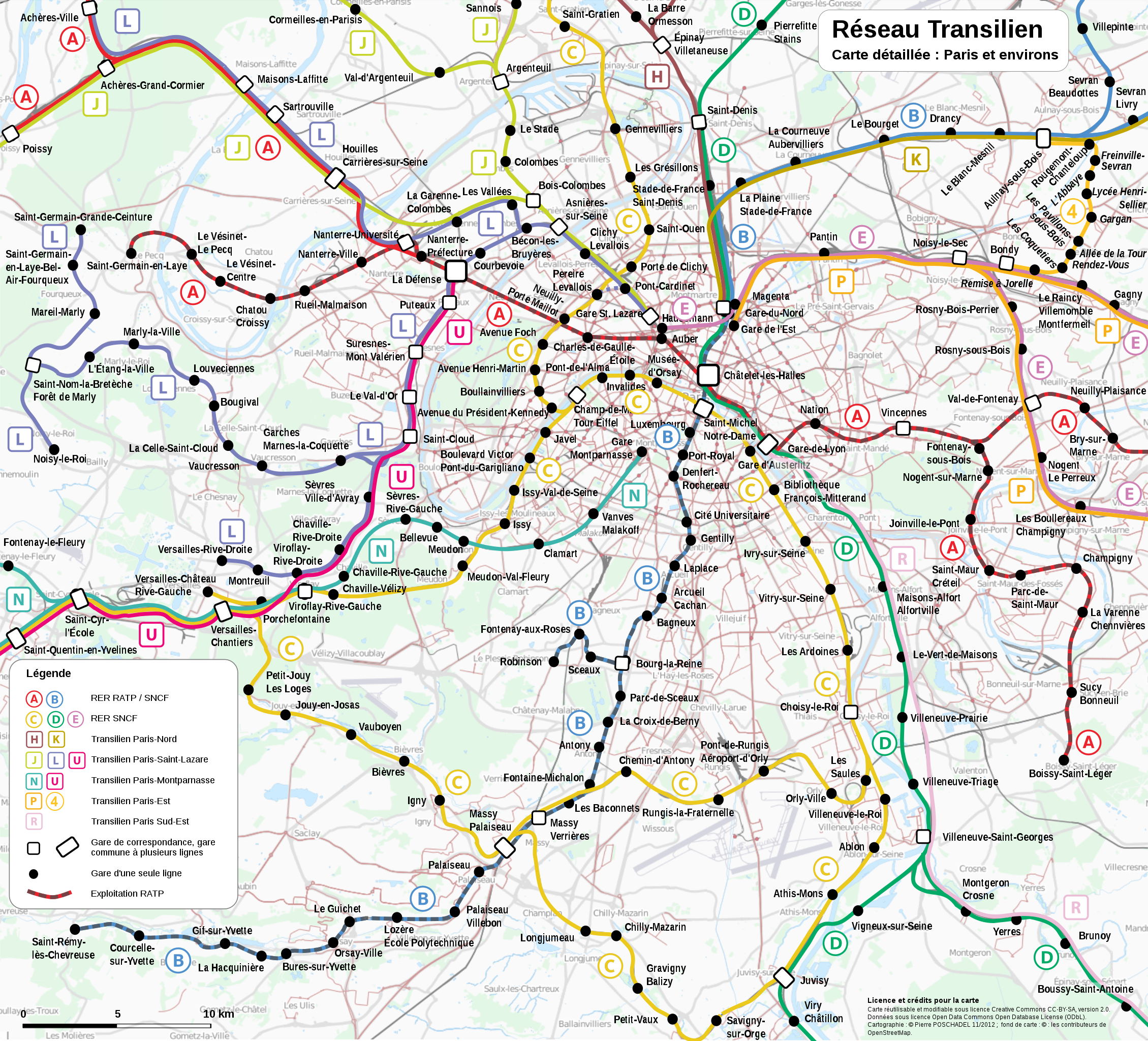
Français : Transilien, carte détaillée Paris et environs. |
| Date | |
| Source | Own work |
| Author | P.poschadel et les contributeurs d'Open Street Map |
| Other versions |
|


Licensing edit
I, the copyright holder of this work, hereby publish it under the following licenses:

|
Permission is granted to copy, distribute and/or modify this document under the terms of the GNU Free Documentation License, Version 1.2 or any later version published by the Free Software Foundation; with no Invariant Sections, no Front-Cover Texts, and no Back-Cover Texts. A copy of the license is included in the section entitled GNU Free Documentation License. |
This file is licensed under the Creative Commons Attribution-Share Alike 3.0 Unported, 2.5 Generic, 2.0 Generic and 1.0 Generic license.
- You are free:
- to share – to copy, distribute and transmit the work
- to remix – to adapt the work
- Under the following conditions:
- attribution – You must give appropriate credit, provide a link to the license, and indicate if changes were made. You may do so in any reasonable manner, but not in any way that suggests the licensor endorses you or your use.
- share alike – If you remix, transform, or build upon the material, you must distribute your contributions under the same or compatible license as the original.
You may select the license of your choice.
File history
Click on a date/time to view the file as it appeared at that time.
| Date/Time | Thumbnail | Dimensions | User | Comment | |
|---|---|---|---|---|---|
| current | 10:13, 28 November 2012 | | 1,469 × 1,332 (2.45 MB) | P.poschadel (talk | contribs) | Petites corrections. |
| 22:24, 27 November 2012 |  | 1,469 × 1,332 (2.46 MB) | P.poschadel (talk | contribs) | {{Information |Description ={{fr|1=Transilien, carte détaillée Paris et environs. }} |Source ={{own}} |Author =P.poschadel et les contributeurs d'Open Street Map |Date =2012-11-27 |Permission = |o... |
You cannot overwrite this file.
File usage on Commons
The following 8 pages use this file:
- File:Paris-public-transports.svg
- File:Transilien, carte de synthèse.png
- File:Transilien, carte de synthèse.svg
- File:Transilien, carte détaillée Paris et environs.svg
- File:Transilien, carte détaillée ensemble du réseau.png
- File:Transilien, carte détaillée ensemble du réseau.svg
- File:Transilien Paris region map.jpg
- File:Transilien Île-de-France map.jpg
File usage on other wikis
The following other wikis use this file:
- Usage on eo.wikipedia.org
- Usage on fr.wikipedia.org
- Usage on id.wikipedia.org
- Usage on ja.wikipedia.org
- Usage on pt.wikipedia.org
- Usage on vi.wikipedia.org
- Usage on zh.wikipedia.org