File:Transoxiana 8th century.svg

Size of this PNG preview of this SVG file: 800 × 388 pixels. Other resolutions: 320 × 155 pixels | 640 × 310 pixels | 1,024 × 496 pixels | 1,280 × 620 pixels | 2,560 × 1,241 pixels | 1,300 × 630 pixels.
Original file (SVG file, nominally 1,300 × 630 pixels, file size: 1.86 MB)
Captions
Captions
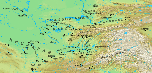
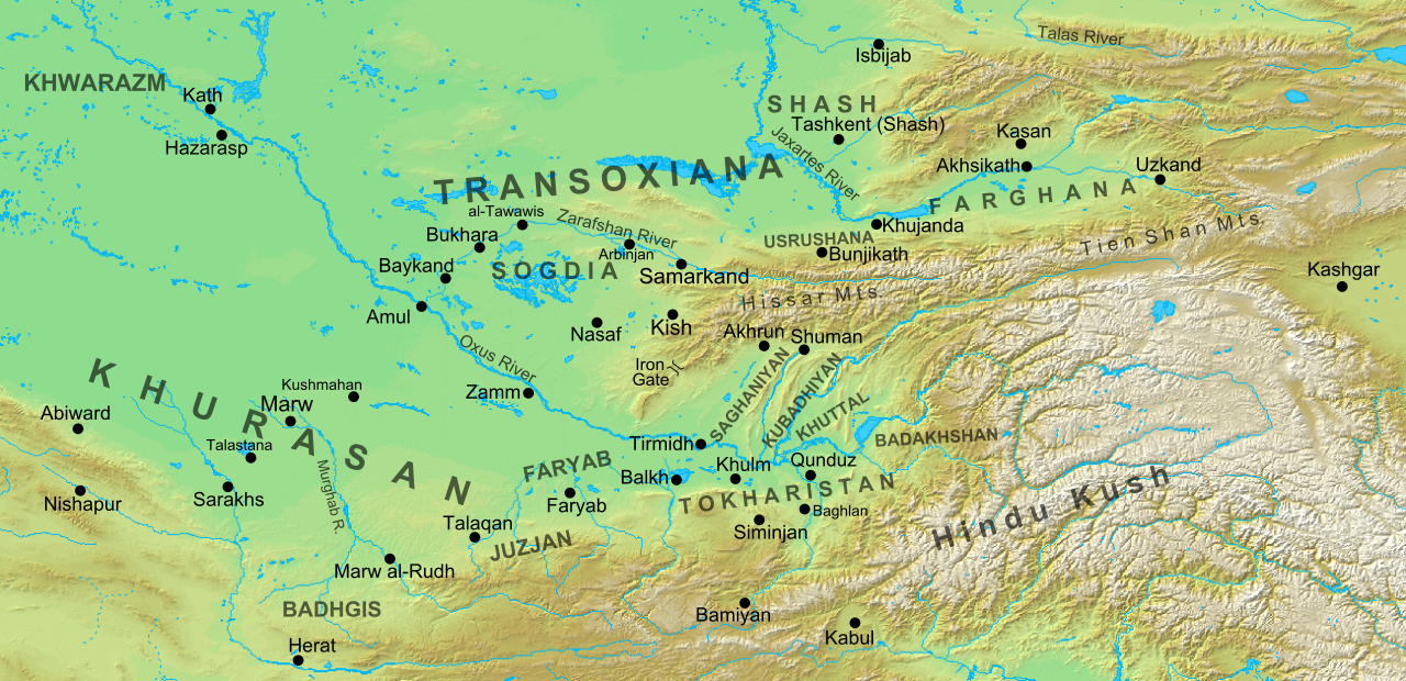
Map of Greater Khorasan, Transoxiana, Khawarazm and Hindu Kush in the 8th century
Summary edit
| Description |
English: Map of the region and principal localities of Transoxiana in the 8th century —.
|
| Date | |
| Source | Own work |
| Author | Cplakidas |
| Other versions |
[]
|


Licensing edit
I, the copyright holder of this work, hereby publish it under the following license:
This file is licensed under the Creative Commons Attribution-Share Alike 3.0 Unported license.
- You are free:
- to share – to copy, distribute and transmit the work
- to remix – to adapt the work
- Under the following conditions:
- attribution – You must give appropriate credit, provide a link to the license, and indicate if changes were made. You may do so in any reasonable manner, but not in any way that suggests the licensor endorses you or your use.
- share alike – If you remix, transform, or build upon the material, you must distribute your contributions under the same or compatible license as the original.
File history
Click on a date/time to view the file as it appeared at that time.
| Date/Time | Thumbnail | Dimensions | User | Comment | |
|---|---|---|---|---|---|
| current | 15:30, 2 October 2016 | | 1,300 × 630 (1.86 MB) | Cplakidas (talk | contribs) | added Qunduz |
| 10:32, 15 October 2012 |  | 1,300 × 630 (1.86 MB) | Cplakidas (talk | contribs) | larger map to include most of Khurasan, additions of cities & provinces | |
| 13:29, 24 January 2012 |  | 800 × 500 (1 MB) | Cplakidas (talk | contribs) | major revision with more additions & corrections | |
| 17:28, 8 December 2011 |  | 800 × 500 (955 KB) | Cplakidas (talk | contribs) | added more details, some corrections | |
| 20:34, 25 July 2011 |  | 800 × 500 (895 KB) | Cplakidas (talk | contribs) |
You cannot overwrite this file.
File usage on Commons
The following 10 pages use this file:
- Atlas of the Caliphate
- User:Cplakidas
- File:Concavemirror raydiagram 2F-ar.svg
- File:Location map of Usrushana.jpg
- File:Transoxiana 8th century-es.svg
- File:Transoxiana 8th century.svg
- File:Transoxiana 8th century - ar.svg
- File:Transoxiana 8th century zh-hans.svg
- Template:Other versions/Transoxiana 8th century
- Category:Khorasan (historical region)
File usage on other wikis
The following other wikis use this file:
- Usage on arz.wikipedia.org
- Usage on azb.wikipedia.org
- Usage on az.wikipedia.org
- Türkdilli dövlətlər
- Usruşana
- Börküyarıq
- Talas döyüşü
- Bahilə qalası uğrunda döyüş
- Susuzluq günü
- Ağsu döyüşü (717)
- Bəykənd döyüşü
- Vikipediya:Həftənin yaxşı məqaləsi/noyabr 2020
- Vikipediya:Həftənin yaxşı məqaləsi/dekabr 2020
- Vikipediya:Həftənin yaxşı məqaləsi/48. Həftə 2020
- Vikipediya:Həftənin yaxşı məqaləsi/49. Həftə 2020
- Böyük Xorasan
- Usage on bg.wikipedia.org
- Usage on bn.wikipedia.org
- Usage on bs.wikipedia.org
- Usage on ca.wikipedia.org
- Usage on cs.wikipedia.org
- Usage on de.wikipedia.org
- Usage on de.wikiversity.org
- Usage on el.wikipedia.org
- Usage on en.wikipedia.org
View more global usage of this file.