File:Tranvía de Sóller.svg

Size of this PNG preview of this SVG file: 800 × 593 pixels. Other resolutions: 320 × 237 pixels | 640 × 474 pixels | 1,024 × 759 pixels | 1,280 × 948 pixels | 2,560 × 1,897 pixels | 1,316 × 975 pixels.
Original file (SVG file, nominally 1,316 × 975 pixels, file size: 436 KB)
Captions
Captions
Add a one-line explanation of what this file represents
Summary edit
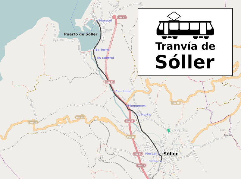
| Description |
Español: Plano del recorrido del tranvía de Sóller |
|||
| Date | ||||
| Source |
English: This map of Soller was created from OpenStreetMap project data, collected by the community. This map may be incomplete, and may contain errors. Don't rely solely on it for navigation.
Español: Este mapa de Sóller fue creado con los datos del proyecto OpenStreetMap, obtenidos por la comunidad. Este mapa puede estar incompleto, y puede contener errores. No se fíe solamente en él para las navegaciones.
Français : Cette carte de Soller a été créée à partir des données du projet OpenStreetMap. Cette carte est peut-être incomplète et peut contenir des erreurs. Ne vous fiez pas uniquement à elle pour vos déplacements.
Italiano: Questa mappa di Soller è stata creata con dati raccolti dal progetto OpenStreetMap. La mappa potrebbe essere incompleta e contenere errori. Non affidarsi esclusivamente ad essa per la navigazione.
|
|||
| Author | OpenStreetMap contributors | |||
| Permission (Reusing this file) |
This file is licensed under the Creative Commons Attribution-Share Alike 2.0 Generic license.
|
|||
| Other versions | Derivative works of this file: Tramvia de Sóller.svg |

Licensing edit
I, the copyright holder of this work, hereby publish it under the following license:
This file is licensed under the Creative Commons Attribution-Share Alike Attribution-Share Alike 4.0 International, 3.0 Unported, 2.5 Generic, 2.0 Generic and 1.0 Generic license.
- You are free:
- to share – to copy, distribute and transmit the work
- to remix – to adapt the work
- Under the following conditions:
- attribution – You must give appropriate credit, provide a link to the license, and indicate if changes were made. You may do so in any reasonable manner, but not in any way that suggests the licensor endorses you or your use.
- share alike – If you remix, transform, or build upon the material, you must distribute your contributions under the same or compatible license as the original.
File history
Click on a date/time to view the file as it appeared at that time.
| Date/Time | Thumbnail | Dimensions | User | Comment | |
|---|---|---|---|---|---|
| current | 18:10, 9 February 2010 | | 1,316 × 975 (436 KB) | Ecelan (talk | contribs) | some stops added |
| 17:28, 9 February 2010 |  | 1,316 × 975 (429 KB) | Ecelan (talk | contribs) | {{Information |Description={{es|1=Ruta del tranvía de Sóller.}} |Source={{own}} |Author=Ecelan |Date=2010-02-09 |Permission={{OpenStreetMap|name=Soller}} |other_versions= }} Category:Tramvia de Sóller [[Category:Tram maps of Spain] |
You cannot overwrite this file.
File usage on Commons
The following 2 pages use this file:
File usage on other wikis
The following other wikis use this file:
- Usage on en.wikipedia.org
- Usage on es.wikipedia.org
- Usage on fr.wikipedia.org
- Usage on gl.wikipedia.org
- Usage on hu.wikipedia.org
- Usage on pl.wikipedia.org
- Usage on uk.wikipedia.org
- Usage on www.wikidata.org