File:Treptow map 1761.png

Size of this preview: 800 × 561 pixels. Other resolutions: 320 × 224 pixels | 640 × 448 pixels | 932 × 653 pixels.
Original file (932 × 653 pixels, file size: 228 KB, MIME type: image/png)
Captions
Captions
Add a one-line explanation of what this file represents
Summary
edit
| Description |
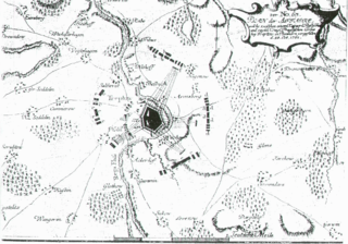
Polski: Plan działań wojennych prusko-rosyjskich w okolicach Trzebiatowa w dniu 25 października 1761 Deutsch: Plan der Affaire welche zwischen einem Kayserl. Rußischen und einem Königl. Preußischen Corps bey Treptow in Pommern vorgefallen d. 25. Oct. 1761. Teilkol. Kupfer aus Seyfart 1764. 18×28,5 cm. Mit Legende. |
| Date | |
| Source | Kriegsgeschichte der Preussen von dem Jahre 1655 bis 1763, Leipzig, 1764. ([1]) |
| Author | Johann Friedrich Seyfart |
| Permission (Reusing this file) |
PD old |
Licensing
edit
|
This work is in the public domain in its country of origin and other countries and areas where the copyright term is the author's life plus 100 years or fewer. | |
| This file has been identified as being free of known restrictions under copyright law, including all related and neighboring rights. | |
File history
Click on a date/time to view the file as it appeared at that time.
| Date/Time | Thumbnail | Dimensions | User | Comment | |
|---|---|---|---|---|---|
| current | 17:54, 2 July 2009 | | 932 × 653 (228 KB) | JDavid (talk | contribs) | {{Information |Description={{de|Plan der Affaire welche zwischen einem .... und einem Koeniglischen Preussischen corps bey Treptow in pommern vorgefallen d. 25. Oct. 1761.}} |Source=unknown |Date=1761-08-25 |Author=unknown |Permission=PD old |other_versio |
You cannot overwrite this file.
File usage on Commons
There are no pages that use this file.