File:Trier-Pfalzel RR bridge B-26 attack2 1944.jpg
Size of this preview: 768 × 600 pixels. Other resolutions: 307 × 240 pixels | 615 × 480 pixels | 984 × 768 pixels | 1,280 × 1,000 pixels | 2,560 × 1,999 pixels | 4,268 × 3,333 pixels.
Original file (4,268 × 3,333 pixels, file size: 3.18 MB, MIME type: image/jpeg)
Captions
Captions
Add a one-line explanation of what this file represents
Summary
edit| Description |
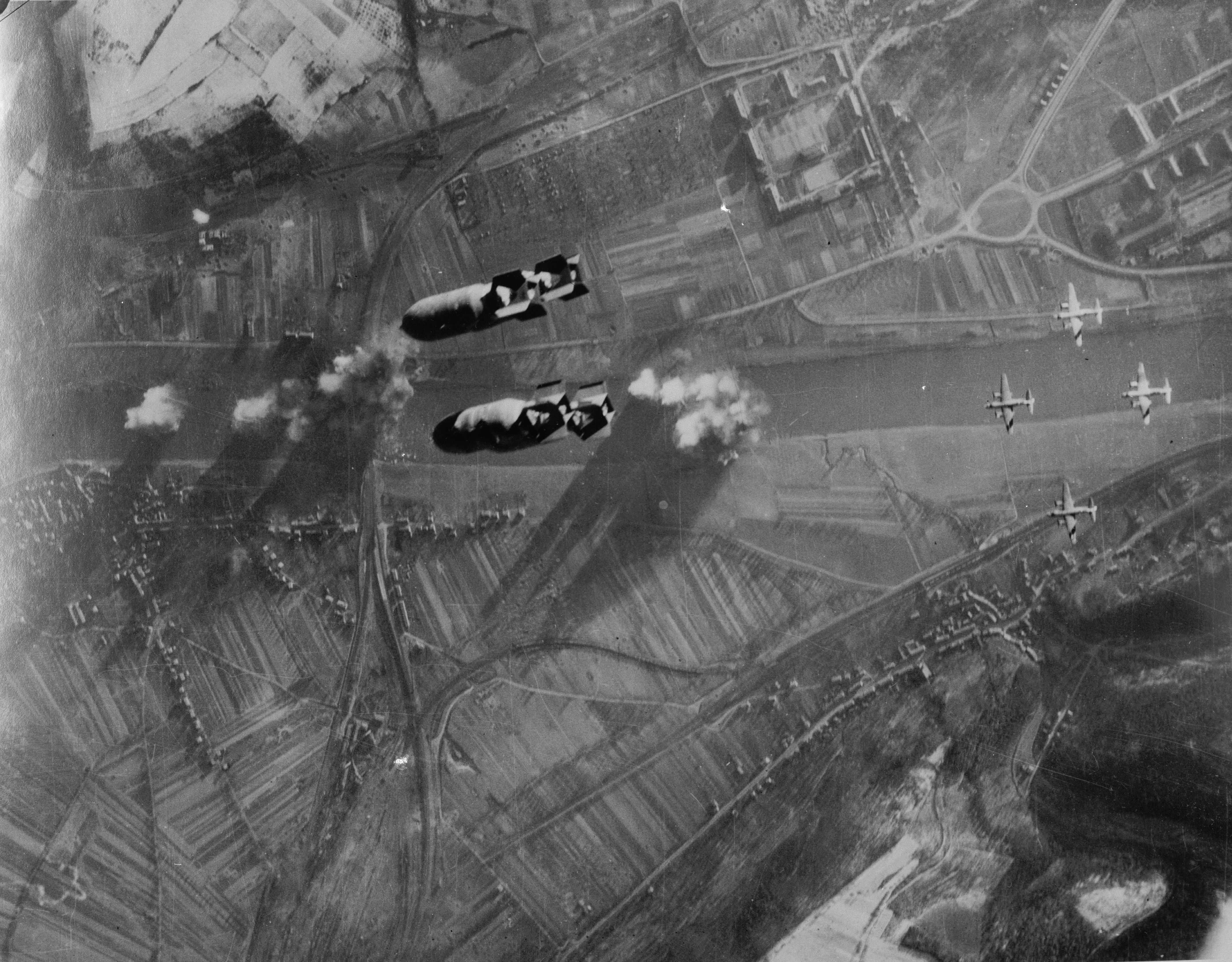
Deutsch: Foto eines Angriffs von Martin B-26 Marauder der USAAF auf die Eisenbahnbrücke über die Mosel in Trier-Pfalzel. Vermutlich zeigt das Foto den Angriff vom 24. Dezember 1944, als 69 B-26 der 323. und 394. Bombergruppe die Brücke mit 122,3 t HE-Bomben angriffen. Der Angriff erfolgte von 13:30h bis 13.45h. Dazu passt die im Süden stehende Sonne, sichtbar an den Schatten der Heckleitwerke auf den linken Tragflächen. Rechts im Bild sind der Verteilerkreis, der Nells Park und die Kasernen an der Dasbachstraße und der Herzogenbuscher Straße zu sehen. Unten im Bild liegt rechts Trier-Biewer, links Trier-Pfalzel und der Verschiebebahnhof Ehrang. Schnee liegt auf den Hügeln.
English: View of an attack of USAAF Martin B-26 Marauder bombers on the railroad bridge across the Moselle river at Trier-Pfalzel, Rhineland-Palatinate, Germany. The photo was probably taken on 24 December 1944, when 69 B-26s of the 323rd and 394th Bomb Group attacked the bridge with 122.3 t of HE bombs. The attack took place between 1330 and 1345hrs, and the sun in the south throws the shadows of the tail fins on the left wings of the B-26s. On the right bank of the Moselle are the Verteilerkreis roundabaout, Nell's Park, and the barracks on Dasbach St. and Herzogenbuscher St. On the left bank are Trier-Biewer (right) and Trier-Pfalzel (left) and the Ehrang rail yard. Snow is visible on the hills. |
|||||
| Date | Taken on 24 December 1944 | |||||
| Source |
|
|||||
| Author | USAAF | |||||
| Other versions | frame removed; File:Trier, Verteilerkreis und Neue Hornkaserne 19441224.jpg |

| Camera location | | View this and other nearby images on: OpenStreetMap |
|---|
Licensing
edit
This image or file is a work of a U.S. Air Force Airman or employee, taken or made as part of that person's official duties. As a work of the U.S. federal government, the image or file is in the public domain in the United States.
|
 |
File history
Click on a date/time to view the file as it appeared at that time.
| Date/Time | Thumbnail | Dimensions | User | Comment | |
|---|---|---|---|---|---|
| current | 21:23, 12 January 2009 | | 4,268 × 3,333 (3.18 MB) | Cobatfor (talk | contribs) | higher resolution |
| 12:57, 4 January 2009 |  | 1,134 × 888 (240 KB) | Cobatfor (talk | contribs) | == Summary == {{Information |Description={{de|1=Foto eines Angriffs von Martin B-26 ''Marauder'' der USAAF auf die Eisenbahnbrücke in Trier-Pfalzel (49,778N, 6,684O). Vermutlich zeigt das Foto den Angriff vom 24. Dezember 1944, als 69 B-26 der 323. und 3 |
You cannot overwrite this file.
File usage on Commons
There are no pages that use this file.
File usage on other wikis
The following other wikis use this file:
- Usage on de.wikipedia.org
- Usage on en.wikipedia.org