File:Triple occupation of Greece el.svg

Size of this PNG preview of this SVG file: 605 × 599 pixels. Other resolutions: 242 × 240 pixels | 485 × 480 pixels | 775 × 768 pixels | 1,034 × 1,024 pixels | 2,068 × 2,048 pixels | 1,158 × 1,147 pixels.
Original file (SVG file, nominally 1,158 × 1,147 pixels, file size: 91 KB)
Captions
Captions
Add a one-line explanation of what this file represents
Summary edit
| Description |
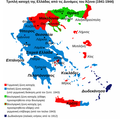
English: Map of the 1941-1944 Axis Occupation of Greece. Depicted are the three occupation zones, plus the geographic regions and major urban centres. |
| Source | https://en.wikipedia.org/wiki/File:Triple_Occupation_of_Greece.png |
| Author | infosfinaki |
| Other versions |
[]
|


_-fr.png)


Licensing edit

|
Permission is granted to copy, distribute and/or modify this document under the terms of the GNU Free Documentation License, Version 1.2 or any later version published by the Free Software Foundation; with no Invariant Sections, no Front-Cover Texts, and no Back-Cover Texts. A copy of the license is included in the section entitled GNU Free Documentation License. |
If this file is eligible for relicensing, it may also be used under the Creative Commons Attribution-ShareAlike 3.0 license. The relicensing status of this image has not yet been reviewed. You can help.
|
File history
Click on a date/time to view the file as it appeared at that time.
| Date/Time | Thumbnail | Dimensions | User | Comment | |
|---|---|---|---|---|---|
| current | 11:55, 4 August 2019 | | 1,158 × 1,147 (91 KB) | Dipa1965 (talk | contribs) | Slightly smaller font size for the map legend |
| 11:43, 9 September 2013 |  | 1,158 × 1,147 (91 KB) | Infosfinaki (talk | contribs) | {{subst:Upload marker added by en.wp UW}} {{Information |Description = {{en|Map of the 1941-1944 Axis Occupation of Greece. Depicted are the three occupation zones, plus the geographic regions and major urban centres.}} |Source = https://en.wikipedia.o... |
You cannot overwrite this file.
File usage on Commons
The following 17 pages use this file:
- User:Magog the Ogre/Maps of conflicts/2019 August
- File:Gr-triple-occupation-ES.png
- File:Gr-triple-occupation-gr.png
- File:Gr-triple-occupation-Česky.JPG
- File:Gr-triple-occupation.png
- File:Occupation-de-la-grece-he.png
- File:Occupation de la grece (1941-1944) -fr.png
- File:PL-triple-occupation.png
- File:Tripla occupazione greca.gif
- File:Triple Occupation of Greece.png
- File:Triple occupation of Greece-zh.svg
- File:Triple occupation of Greece de.svg
- File:Triple occupation of Greece el.svg
- File:Triple occupation of Greece es.svg
- File:Triple occupation of Greece mk.svg
- File:Triple occuppation of Greece el.svg (file redirect)
- Template:Other versions/Occupation of Greece
File usage on other wikis
The following other wikis use this file:
- Usage on el.wikipedia.org