File:Tropical Cyclone Dovi (MODIS 2022-02-11).jpg

Size of this preview: 780 × 599 pixels. Other resolutions: 312 × 240 pixels | 625 × 480 pixels | 1,000 × 768 pixels | 1,280 × 984 pixels | 2,560 × 1,967 pixels | 7,779 × 5,978 pixels.
Original file (7,779 × 5,978 pixels, file size: 4.08 MB, MIME type: image/jpeg)
Captions
Captions
Add a one-line explanation of what this file represents
Summary
edit.jpg&action=edit§ion=1)
| Description |
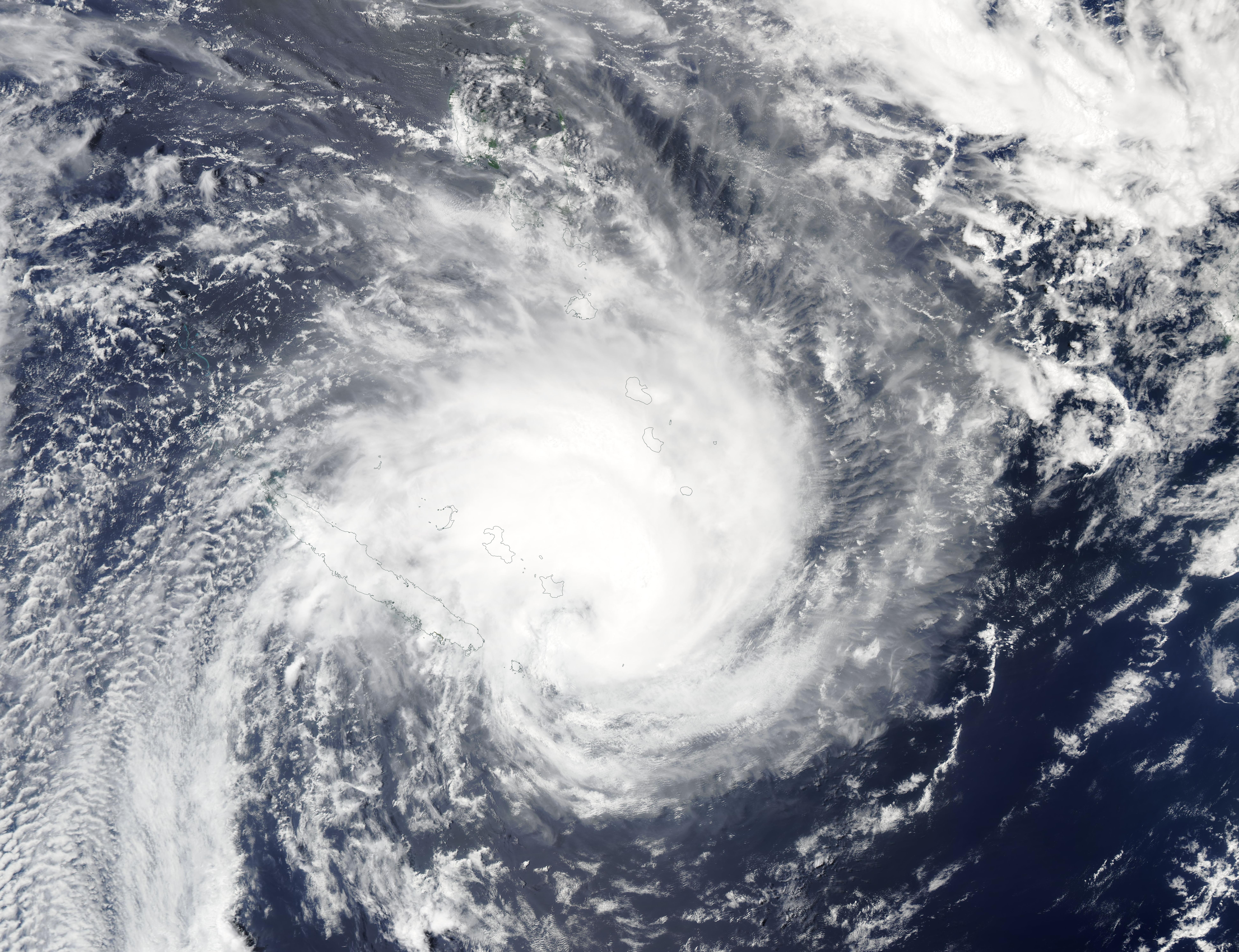
English: On February 10, 2022, the Moderate Resolution Imaging Spectroradiometer (MODIS) on board NASA’s Aqua satellite acquired a true-color image of strengthening Tropical Cyclone Dovi as it exited Vanuatu and took direct aim at the Isle of Pines (L’Ile des Pins), New Caledonia. Just a few hours later, Dovi made landfall over the small island carrying maximum sustained winds near 86 mph (138 km/h). The Isle of Pines, measuring only 15 km (9.3 mi) by 13 km (8.1 mi), sits just east of the long island of Grand Terre. While no early damage reports have yet been published for that island, various media sources report that authorities in New Caledonia have opened shelters in many of the islands, including I’Ile des Pins. Flooding and wind damage has been reported across several islands in Vanuatu.
At 10:00 a.m. EST (1500 UTC) on February 10, the Joint Typhoon Warning Center (JTWC) advised that Tropical Cyclone Dovi was located about 80 miles (129 km) southeast of the city of Noumea, on the island of Grande Terre, New Caledonia and was moving southwestward at 14 mph. Maximum sustained winds remained near 86 mph (138 km/h), but the JTWC remarked that the storm had undergone rapid intensification (from 40 mph to 89 mph) in 24 hours and was expected to continue to rapidly intensify over the next 12 hours, when maximum sustained winds are expected to reach 109 mph (175 km/h). After that time, Dovi will begin to weaken as it battles cooler sea temperatures and increasing wind shear. It is expected to reach New Zealand as a much-weakened extratropical storm on February 12-13. |
||
| Date | Taken on 10 February 2022 | ||
| Source |
Tropical Cyclone Dovi (direct link)
|
||
| Author | MODIS Land Rapid Response Team, NASA GSFC |
| This media is a product of the Aqua mission Credit and attribution belongs to the mission team, if not already specified in the "author" row |
Licensing
edit.jpg&action=edit§ion=2)
| This file is in the public domain in the United States because it was solely created by NASA. NASA copyright policy states that "NASA material is not protected by copyright unless noted". (See Template:PD-USGov, NASA copyright policy page or JPL Image Use Policy.) | ||
 |
Warnings:
|
File history
Click on a date/time to view the file as it appeared at that time.
| Date/Time | Thumbnail | Dimensions | User | Comment | |
|---|---|---|---|---|---|
| current | 22:17, 9 January 2024 | | 7,779 × 5,978 (4.08 MB) | OptimusPrimeBot (talk | contribs) | #Spacemedia - Upload of http://modis.gsfc.nasa.gov/gallery/images/image02112022_250m.jpg via Commons:Spacemedia |
You cannot overwrite this file.
File usage on Commons
There are no pages that use this file.
.jpg&oldid=909384710)