File:Tropical Cyclone Giovanna - NASA Earth Observatory.jpg

Original file (720 × 720 pixels, file size: 256 KB, MIME type: image/jpeg)
Captions
Captions
Summary
edit
| Description |
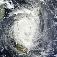
To download the full resolution and other files go to: earthobservatory.nasa.gov/IOTD/view.php?id=77163&src=... Tropical Cyclone Giovanna came ashore in eastern Madagascar as a powerful storm, ripping roofs off houses, downing trees, and cutting power to the capital city of Antananarivo, news reports said. At least one person had been killed. As predicted, the storm weakened after making landfall. By the afternoon of February 14, 2012, wind speeds had dropped to 35 knots (65 kilometers per hour), according to the U.S. Navy’s Joint Typhoon Warning Center (JTWC). This was down from 125 knots (230 kilometers per hour) the day before. The Moderate Resolution Imaging Spectroradiometer (MODIS) on NASA’s Terra satellite captured this natural-color image on February 14, 2012. Having made landfall, the storm appears less organized than it did the previous day, but storm clouds almost completely hide the island of Madagascar. Consistent with earlier predictions, the JTWC forecast that Giovanna would continue moving west, and quickly reorganize over the Mozambique Channel. But the forecast changed between February 13 and 14. Earlier forecasts had called for Giovanna to make landfall in Mozambique, but by February 14, the projected storm track showed Giovanna curving back toward the southeast before reaching the Mozambique coast. Madagascar is no stranger to powerful cyclones. In 2008, Cyclone Ivan killed dozens and left thousands homeless. Likewise, warm waters of the Mozambique Channel have sustained strong storms. Just weeks before Giovanna arrived in the area, Cyclone Funso hovered over the channel for days. NASA image courtesy Jeff Schmaltz, LANCE/EOSDIS MODIS Rapid Response Team at NASA GSFC. Caption by Michon Scott. View more from this event at earthobservatory.nasa.gov/NaturalHazards/event.php?id=771... The Earth Observatory's mission is to share with the public the images, stories, and discoveries about climate and the environment that emerge from NASA research, including its satellite missions, in-the-field research, and climate models. Like us on Facebook Follow us on Twitter Add us to your circles on Google+ |
| Date | |
| Source | Tropical Cyclone Giovanna |
| Author | NASA's Earth Observatory |
| Camera location | | View this and other nearby images on: OpenStreetMap |
|---|
Licensing
edit
- You are free:
- to share – to copy, distribute and transmit the work
- to remix – to adapt the work
- Under the following conditions:
- attribution – You must give appropriate credit, provide a link to the license, and indicate if changes were made. You may do so in any reasonable manner, but not in any way that suggests the licensor endorses you or your use.
| This image was originally posted to Flickr by NASA Earth Observatory at https://www.flickr.com/photos/68824346@N02/6881471251. It was reviewed on 2 July 2012 by FlickreviewR and was confirmed to be licensed under the terms of the cc-by-2.0. |
File history
Click on a date/time to view the file as it appeared at that time.
| Date/Time | Thumbnail | Dimensions | User | Comment | |
|---|---|---|---|---|---|
| current | 17:10, 2 July 2012 | | 720 × 720 (256 KB) | Dzlinker (talk | contribs) | == {{int:filedesc}} == {{Information |Description=To download the full resolution and other files go to: [http://earthobservatory.nasa.gov/IOTD/view.php?id=77163&src=flickr earthobservatory.nasa.gov/IOTD/view.php?id=77163&src=...] Tropical Cyclone Gio... |
You cannot overwrite this file.
File usage on Commons
The following page uses this file:
- File:Tropical Cyclone Giovanna (6881471251).jpg (file redirect)
.jpg&redirect=no)